Tuesday, July 10, 2018

Finishing up the Canadian Gold Trail

Heading north from Whitehorse we hit the remains of the Montague Roadhouse. During the late 1800’s the only form of transportation other than by river was on foot or by horse. Accordingly, distances that could be traveled daily were very limited. Entrepreneurs established roadhouses each some 30 or 40 miles on commonly traveled routes, providing a bed, food and possibly some provisions – and most of all some warm and dry time.

This is all that remains of the Montague Roadhouse. Built at the turn of the century, it was actually built by the White Pass and Yukon Route Railway that eventually connected Whitehorse with Skagway Alaska through the White Pass. When we were in Alaska 10 years ago we actually road the historic route from Skagway to White Pass.
We had been to Dawson City back then as well. But its location on the confluence of the Klondike and Yukon Rivers, surrounded by the high peaks makes it a place worth visiting again. The town itself seems to have changed little. The most prevalent businesses we had frequented were still booming. The town still has no paved streets other than the last mile of the highway, and many of the buildings are very much in decay and unoccupied currently.
The thing that always stuns me about Dawson City is the evidence everywhere of the intense mining at the turn of the century. Dawson City was the epicenter of the late 1800’s gold rush. First mined by hand, then in groups, eventually all the claims were bought up by mining companies and mined using dredges. The dredges would chew up daily what would have taken thousands of men to do and left all tailings in tall mounds that haven’t moved in 120 years. The acre upon acre of tailing mounds may never be dealt with here, unless somehow, they discover an economical way of extracting the fine gold buried in this array of rocks – and there is gold in there they say!


Having been in Dawson City before, we had already visited the home of Jack London, author of Call of the Wild. London had lived in Dawson City as a youth, working the gold fields like all the other hopefuls. He didn’t score any significant gold but did score memories that made for impressive writing later in his life. Almost next door to London lived Robert Service, known as the Bard of the Yukon. Again, we had toured his cabin before, but still sought them both out. They lived close enough that they could have tossed plot ideas to each other.
We finally decided to venture up the Dempster Highway. The Dempster is claimed to be the first highway to travel up north of the Arctic Circle. Lile the Dalton Highway in Alaska that goes from Fairbanks to Prudhoe Bay, the Dempster is unpaved due to the permafrost that would tear apart a paved roadway in no time. Along the way we found Tombstone Territorial Park.
The Dempster runs through beautiful mountain ranges all the way from Dawson City to Inuvik on the Arctic Sea. There is only one small town on this 460-mile dirt highway about half way to Inuvik, Eagle Plains. The highway was named after the famous Yukon Mountie William Dempster who earned renowned for his discovery of the lost patrol.
 In February 1911, Francis Joseph Fitzgerald led a mail patrol from Fort McPherson bound for Dawson City. When they never arrived, Dempster was sent out to investigate and found the bodies of Fitzgerald and his party. It was logged as one of the Yukon’s greatest tragedies. However we discovered another one – since the snow in this area only lifted recently, we assume this semi has been here for months.
Talk to you soon!

Saturday, July 7, 2018

The mighty Yukon - gateway to gold

We continued north through the various Canadian gold fields. We stopped in again at Watson Lake where they tout the world’s largest sign jungle. When we were here 10 years ago we thought it was really big. But it is at least 10 times bigger now. We are not sure that it has room to get a lot bigger, maybe a few more years until they are out of space!

Coming out of British Columbia we had a good day – 7 bears, a porcupine and several hundred bison. I am not sure our claim holds for the bears as it was actually only 4 sightings – one of our sightings was a great big momma along with 3 little cubs. We weren’t aware that northern BC had a considerable population of bison. We drove a long way after seeing the caution sign but hadn’t seen a single one. Then all of a sudden, they were everywhere! We also saw a caution sign warning about a large migrating herd, the Forth Mile Herd, of caribou, but we never did spot them. Might be the wrong season.
We then set out to revisit the Yukon River and the town of Whitehorse. The Yukon River fed most of the miners lusting to strike it rich in the Canadian Gold Rush. Between it and the Mackenzie, it brought the majority of the supplies into the gold bearing areas. While riverboats no longer plied these rivers once the railroads arrived, there era left much to admire. The 3rd longest river in North America, the watershed of the Yukon River is considerably larger than the state of Texas.
We learned that locals have decided to change the names of their towns from what the founders named them. They keep the theme but modify them nonetheless. For example, the residents of Caribou Crossings apparently found that name too cumbersome to use routinely. So, in the early 1900’s, they have shortened it to Carcross. But I think you can take a thing too far as well. The founders named it White Horse in deference to the White Horse Rapids that mane of a horse. In 1957 the locals decided to shorten the name – to Whitehorse. As far as I can tell, it’s the same number of characters. Maybe they wanted to save the ink from not having to print a capital W, or it was just making the name take up one less space on a printed page. None of these thoughts to me justify the cost to change a cities name!
Just south of Whitehorse we discovered Miles Canyon. This was an infamous barrier to the gold miners rushing to Dawson City. The Yukon narrows here to rush through a basalt lava canyon under 100 feet wide. Before the hydro dam was built downstream the rapids here were navigable by only the most skilled and experienced captains. Many hundreds died in the canyon, before a tramway system was built. Miners would stop above Miles Canyon and unload their goods. The tram would transport their goods to a point below the Canyon. Then they would hire an experienced captain to guide their boat through the treacherous rapids. Today, the dam makes the Canyon look like just a pleasant paddle!
Just north of Whitehorse a way we discovered the Five Finger Rapids. At this point, four islands divide the Yukon into five narrow channels. Again, many lives were lost until it was determined that only the eastern channel was able to be navigated, and even then, it wasn’t always successful. A solution eventually made these rapids safer and even allowed for steam powered riverboats to make their way from White Horse to Dawson City. A very heavy cable was anchored to the rocks both above and below the rapids. When a boat came to the rapids, it attached to the cable which helped it stay stable through the torrent, and then detached at the end.
We drove a way up the Klondike Highway to take in the beauty of Emerald Lake. Apparently, the bottom of this lake has white deposits of marl, which causes the sunlight to be reflected in a neon emerald appearance. Marl is a mixture of clay and calcium carbonate. The shallower the lake where there are such deposits, the brighter the neon emerald appears.
I am sure we have mentioned this before, but the amount of graffiti in Canada is so much more than what we see in the states. We see rocks with graffiti, entire hillsides with graffiti, and many various objects in the cities covered with it. However, occasionally they even make me chuckle. Apparently, this artist liked the more physical sports than just hiking or cross-country skiing.
And holy cow do they have big families in Canada. I have seen either front-back or side-side strollers in the states, and I am pretty sure I have even seen a stroller with 3 side by side seats. But I have never seen a stroller like this beast!
We got in one last walk around town with the pooch and made it a point to stroll the path along the Yukon River before we headed on. We had explored this grand riverboat that used to ply the waters of the Yukon when we were hear 10 years ago, but it was still nice to have a sit down between it and the river.
Talk to you soon!

Wednesday, July 4, 2018

Alcan at last!

In order to get to Alaska by vehicle there is only one road in and out – the Alaska Highway or the Alcan (Alaska/Canada Highway). Although we didn’t need to start at mile marker zero, Dawson Creek was only about a half hour out of our way, so we decided to start our slog there.

On the way to Dawson Creek we stopped in Chetwynd, the chainsaw carving capital of the world. We had been here the last time we visited Alaska, but the carvings are always new, and the sight of the hundreds of them lining the highway is a visual treat. We stopped here for lunch at A&W and the Woman wanted deep fried cheese curds, something all US A&W’s serve. So, I ordered cheese curds, and when we opened the to go bag back at the coach, we found a plastic wrapped handful of chilled curds – naked, not breaded and deep fried. The Woman was deeply disappointed.
In Prince George we found the town had been flooded by hundred-year rains and was only just drying out when we arrived. We managed to find the bike trail along the Fraser River, but could only do part of it. The Fraser, because of the heavy rains, was historically high and had swallowed up huge chunks of the trail.
We also hit the local movie theater in Prince George as many of the small towns we are hitting don’t even have them. Although we didn’t go to see it, that day happened to be the opening of Jurassic World. They sure know how to put on a party up here.
In a Provincial Park outside Fort St. John we spotted our first Ptarmigan. The only place we had ever seen Ptarmigan was in Alaska, referred to up there as the Alaska Chicken. I guess it is fitting that if we spot a Ptarmigan outside of Alaska that at least it is along the Alaska Highway.
We dodged a huge bullet in Fort St. John. Pulling out of a gas station there were barriers to limit turns, and they were in no way large vehicle friendly. Running up on the sidewalk, a depression resulted in the axel resting on the curb, and Colectiva was totally stuck, drive wheels off the ground. At least a half dozen Canadians helped me to use the leveling jacks to raise up the rear of the coach, place a bunch of jack pads under the rear tires, lower the jacks again and drive off the curbing – in the mean time pissing off dozens of Canadian drives as we totally blocked half the road. Then, getting back to the RV Park we were staying at, we had to contend with the normal things you contend with living in RV Parks.
We are starting to see a fair bit more wildlife the further north we get. On the Alcan between Fort St. John and Fort Nelson we managed to see a huge black bear. We had seen bear on the road to Barkerville, in fact a couple of them. But we had yet to see one just nibbling along the side of a major highway – bonus!
I had to pull over when I spotted this but stopping 10 tons of motorhome and toad is no easy matter. So, I had to run back quite a ways in order to get a close up look. But it was worth the run. We passed this spot on our last trip to Alaska – no other way around it. But I guess I wasn’t looking very carefully back then.
Outside Fort Nelson the Woman suddenly spotted some very large water birds. I said they looked oddly like Sandhill Cranes. Turns out that they were. It turns out that Sandhill Cranes migrate annually through British Columbia between their nesting grounds in Alaska and their wintering grounds in the southern United States. We had seen them in Texas before, but really didn’t expect to see them way up here!
Talk to you soon!

Sunday, July 1, 2018

Quesnel BC

So, apparently you don’t pronounce the “S”. This was pretty much our last stop on the Cariboo Gold Trail. There were other gold rushes in different places, but this one rivaled the discovery at Sutter’s Mill. To honor all the dozens of people important to the history of this town, they have made all their fire hydrants into images of those folk. We enjoyed walking around town checking them out but could have used a guide – had no idea who we were looking at!

We headed to Barkerville. Named for Billy Barker, the miner who placed the first gold claim in this area, Barkerville was the biggest town in BC in the 1860’s population wise, but when the gold entirely played out, the town was totally abandoned.  The town has been recreated to look like the 1860’s, with many of the buildings being the actual structures from that time.
In Barkerville we learned all about Chinatown and why they exist everywhere, explained to us by an actual descendant of a Barkerville Chinese resident. Generally, the Chinese weren’t very welcomed anywhere they came. As a result, they essentially set up all their own support mechanisms, setting up stores, banks, and everything they needed that they could not count on the white Europeans to provide. That helped the Chinese, but further separated them from the locals, who received little or none of their economic commerce.
We also learned that at the time of the gold rushes/transcontinental rail projects, the area around Hong Kong – Guangzhou China – was the only part of China that the then government allowed international trade. – Guangzhou in English is Canton. The Chinese believed that to emigrate from China was unpatriotic, and those caught trying to flee China were executed. The people of Guangzhou are the only ones who were able to get communications from the outside world about the gold discoveries in the US and Canada, so the only Chinese to be aware. In addition, the harshness of the domestic government caused many of the locals to risk death, and hop British ships bound for the west coast of North America. That, for the most part, is why when you old farts were a kid, you could only find Cantonese food in the US.
We also hit Wells British Columbia where a gold strike not terribly long after the strike by Billy Barker resulted in a rush to this community. While Barkerville is gone, now only a historic park, Wells still has a hundred or so residents and a few local businesses. We grabbed lunch, which ended up being a cold premade sandwich as no hot food could be found in Wells in the lunch hour.
We also spent some time at the local education center for First Nation folk. We happened to be in Quesnel for National Indigenous Peoples Day, or National Aboriginal Day. Despite the fact that Canadians treated locals really no better than Americans did at the time, it seems like Canadians do a better job of brining current focus on the folk that were here before them.
On the way to Barkerville we found the gravesite established by folk who were part of the Cariboo Gold Rush. Back then, a large number of the folks who needed burying were Chinese. They were buried in the local cemetery along with the white Europeans. Apparently Chinese belief is that in order to find peace, the remains of their loved ones need to be in China, so most of the graves of Chinese folk were exhumed here, and their remains were sent to China to be buried there. We saw lots of the grave sites where obvious excavation had occurred at some time – kinda creepy!
Apparently when you are in such a rural setting, you need to do whatever you need to do to make a living, and to run a business that will last. Can you think of any more services that could be provided by this Wells British Columbia establishment?
In Barkerville they put on a vaudeville style production that brought to life a little of what it might have been like to be here in the 1860’s. We thoroughly enjoyed it!
Talk to you soon!

Thursday, June 28, 2018

A good day

The Woman had been complaining a lot. We’ve been in this beautiful country for several weeks now. We’ve seen all the warning sings on the highway that we might be encountering all forms of wildlife on the highway for the next X kilometers. But we have yet to see anything resembling a mammal anyway near our route – until today!

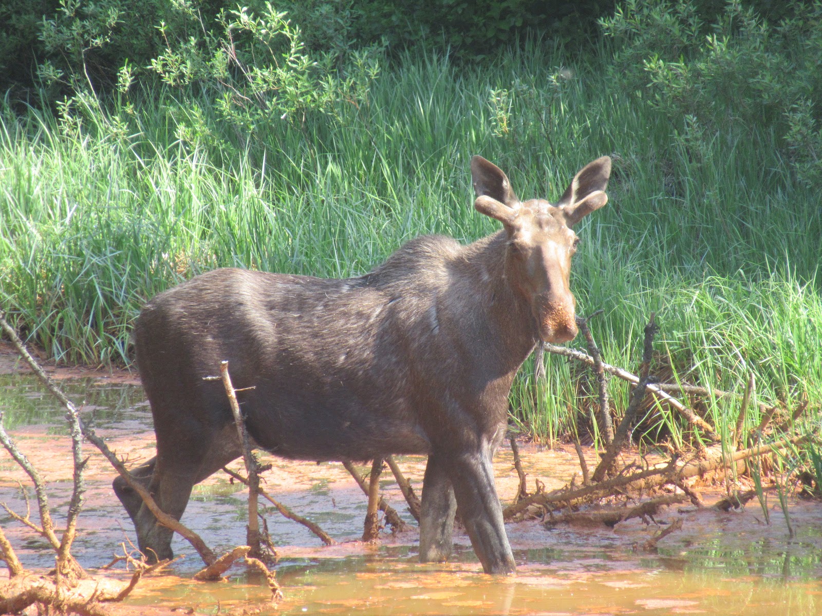
We ended up having a very good day. We headed out of Quesnel toward Barkerville. Barkerville was one of the richest of the gold areas discovered during the 1880’s Cariboo Gold Rush. We were pleased that in addition to the dear we spotted earlier, that we spotted this mommy Moose along the side of the road. A twofer is good, right?
Then when we were on the road the Woman said “Look at the coyote.” Well, I looked, but it wasn’t no coyote. The Woman said maybe it was a dog. It wasn’t no dog. I told the Woman that it was a Fox. I learned later that Red Fox are common in this area. So, a threefer – we hadn’t seen any wildlife other than Marmots in Canada so far, and we get a hit on three. Good day!
And then out of nowhere we hit the biggie. We had wanted to see a bear and had been in all kinds of areas that had bear resistant trash receptacles, but no bear spotting occurred. So, we kinda thought we would have to wait until Alaska to see a bear. Well, no waiting needed. We saw this guy roaming the side of the road, and darn proud of it. Having logged a fourfer, we were quite content for our day.
Talk to you soon!

Monday, June 25, 2018

Ashcroft BC

We got an email from the RV Park we had reservations at in Cache Creek that they were flooded and were closed for repair. We ended up in nearby Ashcroft at a city owned park with about a dozen campsites with electric and water. Being literally feet from the Thompson River it was wonderful, except for also being feet from not one, but two relentless rail lines, always blasting their arrival as small-town railroad crossings have limited safety automation.

In the late 1800’s, the Canada Pacific Railroad connected small Ashcroft to the rest of Canada. Being the closest point that rail got to the Cariboo gold strikes, Ashcroft boomed as a supply town to the miners. Anything that they needed could be easily brought in by rail to Ashcroft, and at a reasonable price. After the gold panned out, the local Chinese population left over from the railroad construction crews began to grow potatoes and tomatoes – irrigating the sandy volcanic soil resulted in fertile agricultural land. At the turn of the century, the CPR served Ashcroft grown potatoes in all their restaurant cars exclusively because they were so good!
In 1975 the graduating class at the local secondary school wanted to place a graduation marker on the bluffs of the Thompson overlooking town. The town embraced this, not only as a way to recognized their local citizens, but also to keep graduating seniors busy, and reduce the amount of otherwise resulting graffiti. Apparently, it worked, and the tradition is still going today.
We headed out to Lillooet to get back to the gold trail on the Fraser River. We had been making our way up the Fraser River from Hope a while ago but decided to leave Lillooet for when we made our way back west a bit. The rough and tumble Fraser was every bit as powerful as we remembered.  In Lillooet we discovered the Mile 0 marker for the original Cariboo Gold Trail.
We visited what is now referred to as the Miyazaki House. Built by locals Caspar and Cerise Phair, it is one of the oldest structures still standing in Lillooet. It’s most famous owner was Dr. Masajiro Miyazaki, who after being interned nearby during the War, bought the home in 1945 when Canada lifted the ban on Japanese ownership of property. 
We also visited the old Bridge of the 23 Camels. During the Civil War, the US Army experimented with the use of camels as pack animals. While hardy, their personalities and habits made them unwelcome to soldiers, and the Army abandoned the experiment. Miners in Lillooet bought 25 of the US Army camels and transported them to work on the gold trail – 2 died along the way and 23 eventually were packing mining gear all over this part of BC. Eventually even the miners couldn’t stand the biting and spitting, and the government outlawed their use as pack animals.

We spotted this majestic Osprey overlooking its territoryy along the Thompson River.
Were finding that as we head north we are encountering more bugs, and the mosquitoes keep getting bigger, hungrier and more aggressive. But even the mosquitoes who are most annoying don’t hold a candle to these guys!
Talk to you soon!

Friday, June 22, 2018

Kamloops BC

Kamloops is the largest city in the region. Its history dates back to the 1800’s, with trading company forts, supplying the Cariboo Gold Rush, and the arrival of the transcontinental railroad. However, we didn’t see much of that history in action here, with historical sites or historic buildings. At least the city was big enough that we got to take in Solo, a Star Wars Story finally, so our visit was rewarding.

Without all the historical draws, we packed up the pooch and headed down to Riverfront Park. Kamloops lies at the confluence of the north and south legs of the Thompson River, a huge park between the old rail right of way and the Thompson taking advantage of the gorgeous river views. Sadly, when we got there, we learned that dogs were not allowed in the park, even on leash. Oh well – no history, no dogs – not very welcoming! At least there is a wine industry along the river, so we stopped at Harpers Trail Estate Winery for some tasting and got a break in the weather, sitting on their very scenic patio with a chilled bottle of their gewürztraminer.

There was a bonus here – the Woman was nearly out of one of her prescriptions and we learned you can’t get a prescription filled in Canada unless it’s written by a Canadian doctor. In Dallas BC (yes, there is a Dallas BC) we found a very helpful local pharmacist that was willing to figure out the Canadian equivalent of the Woman’s pills and give her a two-week emergency supply to get her to Alaska. What a nice experience. And as a second bonus, we spotted a proud Magpie. This was not the first time we have ID’d a Magpie, but this guy was particularly large, and particularly proud. It capped off a very nice day for us.
Talk to you soon!