Thursday, June 28, 2018

A good day

The Woman had been complaining a lot. We’ve been in this beautiful country for several weeks now. We’ve seen all the warning sings on the highway that we might be encountering all forms of wildlife on the highway for the next X kilometers. But we have yet to see anything resembling a mammal anyway near our route – until today!

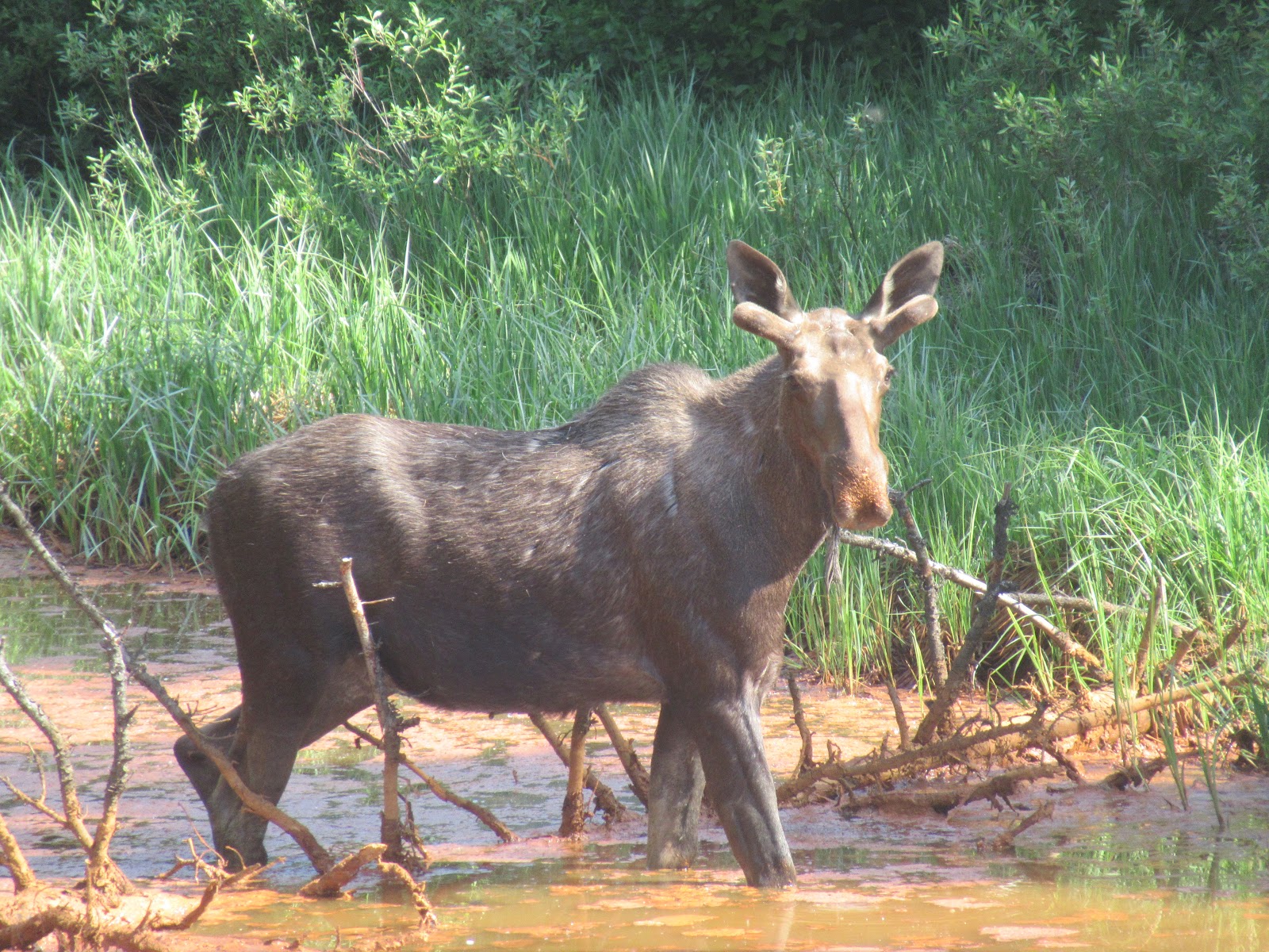
We ended up having a very good day. We headed out of Quesnel toward Barkerville. Barkerville was one of the richest of the gold areas discovered during the 1880’s Cariboo Gold Rush. We were pleased that in addition to the dear we spotted earlier, that we spotted this mommy Moose along the side of the road. A twofer is good, right?
Then when we were on the road the Woman said “Look at the coyote.” Well, I looked, but it wasn’t no coyote. The Woman said maybe it was a dog. It wasn’t no dog. I told the Woman that it was a Fox. I learned later that Red Fox are common in this area. So, a threefer – we hadn’t seen any wildlife other than Marmots in Canada so far, and we get a hit on three. Good day!
And then out of nowhere we hit the biggie. We had wanted to see a bear and had been in all kinds of areas that had bear resistant trash receptacles, but no bear spotting occurred. So, we kinda thought we would have to wait until Alaska to see a bear. Well, no waiting needed. We saw this guy roaming the side of the road, and darn proud of it. Having logged a fourfer, we were quite content for our day.
Talk to you soon!

Monday, June 25, 2018

Ashcroft BC

We got an email from the RV Park we had reservations at in Cache Creek that they were flooded and were closed for repair. We ended up in nearby Ashcroft at a city owned park with about a dozen campsites with electric and water. Being literally feet from the Thompson River it was wonderful, except for also being feet from not one, but two relentless rail lines, always blasting their arrival as small-town railroad crossings have limited safety automation.

In the late 1800’s, the Canada Pacific Railroad connected small Ashcroft to the rest of Canada. Being the closest point that rail got to the Cariboo gold strikes, Ashcroft boomed as a supply town to the miners. Anything that they needed could be easily brought in by rail to Ashcroft, and at a reasonable price. After the gold panned out, the local Chinese population left over from the railroad construction crews began to grow potatoes and tomatoes – irrigating the sandy volcanic soil resulted in fertile agricultural land. At the turn of the century, the CPR served Ashcroft grown potatoes in all their restaurant cars exclusively because they were so good!
In 1975 the graduating class at the local secondary school wanted to place a graduation marker on the bluffs of the Thompson overlooking town. The town embraced this, not only as a way to recognized their local citizens, but also to keep graduating seniors busy, and reduce the amount of otherwise resulting graffiti. Apparently, it worked, and the tradition is still going today.
We headed out to Lillooet to get back to the gold trail on the Fraser River. We had been making our way up the Fraser River from Hope a while ago but decided to leave Lillooet for when we made our way back west a bit. The rough and tumble Fraser was every bit as powerful as we remembered.  In Lillooet we discovered the Mile 0 marker for the original Cariboo Gold Trail.
We visited what is now referred to as the Miyazaki House. Built by locals Caspar and Cerise Phair, it is one of the oldest structures still standing in Lillooet. It’s most famous owner was Dr. Masajiro Miyazaki, who after being interned nearby during the War, bought the home in 1945 when Canada lifted the ban on Japanese ownership of property. 
We also visited the old Bridge of the 23 Camels. During the Civil War, the US Army experimented with the use of camels as pack animals. While hardy, their personalities and habits made them unwelcome to soldiers, and the Army abandoned the experiment. Miners in Lillooet bought 25 of the US Army camels and transported them to work on the gold trail – 2 died along the way and 23 eventually were packing mining gear all over this part of BC. Eventually even the miners couldn’t stand the biting and spitting, and the government outlawed their use as pack animals.

We spotted this majestic Osprey overlooking its territoryy along the Thompson River.
Were finding that as we head north we are encountering more bugs, and the mosquitoes keep getting bigger, hungrier and more aggressive. But even the mosquitoes who are most annoying don’t hold a candle to these guys!
Talk to you soon!

Friday, June 22, 2018

Kamloops BC

Kamloops is the largest city in the region. Its history dates back to the 1800’s, with trading company forts, supplying the Cariboo Gold Rush, and the arrival of the transcontinental railroad. However, we didn’t see much of that history in action here, with historical sites or historic buildings. At least the city was big enough that we got to take in Solo, a Star Wars Story finally, so our visit was rewarding.

Without all the historical draws, we packed up the pooch and headed down to Riverfront Park. Kamloops lies at the confluence of the north and south legs of the Thompson River, a huge park between the old rail right of way and the Thompson taking advantage of the gorgeous river views. Sadly, when we got there, we learned that dogs were not allowed in the park, even on leash. Oh well – no history, no dogs – not very welcoming! At least there is a wine industry along the river, so we stopped at Harpers Trail Estate Winery for some tasting and got a break in the weather, sitting on their very scenic patio with a chilled bottle of their gewürztraminer.

There was a bonus here – the Woman was nearly out of one of her prescriptions and we learned you can’t get a prescription filled in Canada unless it’s written by a Canadian doctor. In Dallas BC (yes, there is a Dallas BC) we found a very helpful local pharmacist that was willing to figure out the Canadian equivalent of the Woman’s pills and give her a two-week emergency supply to get her to Alaska. What a nice experience. And as a second bonus, we spotted a proud Magpie. This was not the first time we have ID’d a Magpie, but this guy was particularly large, and particularly proud. It capped off a very nice day for us.
Talk to you soon!

Tuesday, June 19, 2018

Revelstoke BC

We got to score a couple of lifers in Revelstoke British Columbia. We got to hit the Canadian portion of Glacier National Park. While many of the US glaciers have completely disappeared, there are about 100 active glaciers in the Canadian version of Glacier National Park. While we couldn’t hike a great deal because most of the hiking trails were still under snow, we did manage to hit the visitor center, capture a few geocaches, and hike to our hearts content.


We discovered the Revelstoke Dam, one of more than 60 on this amazing resource for our two countries. We learned surprisingly that over 95% of power in the Province of British Columbia is hydro generated. The Dam is the 5 largest in the world from a power generation viewpoint and will likely move up. When the Dam was finished, only 4 of the 6 possible penstocks for power generation were completed. Since then, a 5th has been added, and there is still room for one more.
We also managed to make it to Mount Revelstoke National Park. Revelstoke as a town pretty much only exists because of the Canadian Pacific Railway. In the 1870’s the CPR was looking for a way across the Rocky Mountains that would allow it to connect the east and west coasts of Canada, preserving the nation’s wealth. In 1881 they hired A. B. Rogers to find such a pass, and in 1882 he discovered what is now referred to as Rogers Pass. The CPR plowed rail through the Pass and completed the transcontinental railroad, but the pass proved to be at constant risk of avalanche, and in the winter time, a full-time staff lived alone along the rail like attempting to keep it free of snow.
On March 4, 1910 an avalanche had completely closed the line, and a crew of 60 men set out to clear it. With the line nearly clear, supervisor John Anderson left the crew and headed to the work shack to contact Revelstoke and let them know that the rail would soon be clear. After he left, another avalanche came from the opposite canyon wall, and killed all 58 men still working, including John Anderson’s brother. The CPR still travels through this corridor, but now uses a 5-mile-long tunnel to bypass the worst of the avalanche area.

Apparently, the climate and terrain here attracted Scandinavians. We hiked the Soren Sorenson trail in Mount Revelstoke NP several times, and we also discovered the historic Nels Nelson Ski Jump. Built in 1916 and known locally as the Big Hill, this ski jump set the pace for Canadian ski jumping for decades to come. Now inside the NP, ski jumping records were set here from the day it opened until 1932.
During his career Nels set Canadian records 5 years and set many world records that would stand for many years. Locally they refer to 1931 as the year of the Great Fiasco. When a world competition came to Revelstoke, the judges concluded that Nels Nelson’s Big Hill was too big and steep to be safe for competitive jumping and demanded that a lower launch point be used. Although the locals still posted huge jumps from the Big Hill, the judges disqualified all those jumps.

Al
though I mentioned the preponderance of Scandinavians, Canada is truly a melting pot of people from all over the world. While I would not have necessarily thought of this combination of ethnic food, apparently it works well in Canada, or at least in Revelstoke. We actually had lunch here and found it really nice.
We discovered Revelstoke Mountain Resort, and massive ski complex just a few miles from downtown. We hopped on the gondola and headed up to the first stop on the massive hill and hiked around to very picturesque views of the Columbia River. The gondola continued up to the summit of the resort, but sadly that was still under many feet of snow, so wasn’t open.
Oh, I forgot to mention that Revelstoke is on the Columbia River. I didn’t know this but the source of the Columbia is way up in norther BC. I was a bit confused that Simon Fraser had originally thought the Fraser River that he explored in 1806 was the Columbia River. Now I know that the Columbia actually travels in all four directions, north, south, east and west in different parts of BC. Then it heads south and forms most of the border between Washington State and Oregon.
The Columbia River is impressive here. We traveled along it for much of our venturing in Mount Revelstoke and Glacier National Parks. We found it again in the town of Golden on the east side of Glacier NP. We found the longest wooden covered pedestrian bridge in Canada straddling the Columbia in Golden. We will also travel it some more as we head toward Kamloops tomorrow.


Canadians just love their camping and RV travel. If you don’t happen to own your own RV it’s really no problem at all. I know it happens in the US as well, but RV rental in Canada seems like a way of life. And while there are some interesting variations, RV rental in Canada pretty much means a Class C unit on a Ford chassis.
Of course, the nonstop waterfalls continue. We hit Moses Falls along with a plethora of others. Each and every hike we take gets us up close and personal with a waterfall. The Woman loves it. To be honest, so do I!
Talk to you soon!

Saturday, June 16, 2018

Kelowna BC

We wanted to mosey along the Canadian Gold Trail. Leaving Hope, we ventured north along the Fraser River through Lytton near where on March 23, 1858, Edward Hill and two other Americans from San Francisco stopped for lunch. Hill saw yellow objects glinting from the rocks near the river’s edge and grabbed his pan. After they sent large pouches of gold to the assay office, word was out and the Cariboo Gold Rush was in full force. To this day, Hill Bar was the richest stake anywhere in the area.

Kelowna is the largest city in BC that is not on the Pacific Coast. It is home to the Okanagan Valley and its many vineyards. We visited a few, but the most interesting (except for the wine that is) was Frequency Vineyards. A local musician believed he saw what loud musical frequencies did to the settling of sediment in wines. He built a winery where all his wines are subjected to loud frequencies which allegedly allow them to age in hours instead of months. The other wineries were more traditional – this one was fun.
We learned that there must be a bunch of little folk, dwarfs, that enjoy the RV lifestyle. No matter where we go, we see shade covers over picnic tables that could not be much more than 4 feet high. At least, that is what we assume.
Thanks to our friends Ron Ezra and Teresa Bell, we found the Myra Canyon section of the Kettle Valley Railway. Built beginning in 1910, this particular section sported 18 railroad trestles and 2 tunnels in a 9-mile stretch. When the railroad abandoned the line, locals worked tirelessly to adapt the rail bed and the trestles to allow for a walking/biking trail that is simply spectacular!
It turns out that this is the exact same railroad that built the Othello Tunnels near Hope BC. While the Othello Tunnels were cool, this 18-trestle section is even more so. We biked it on one day and loved it so much that we came back the next day with Kona and walked the trail again!
It is hard to imagine how they would have maintained this rout at the turn of the century. Both days we were here there was heavy equipment clearing slides that happened the night before, and the debris on the path was substantial. On the trestles we thought it was cool that they had viewing platforms levered off the side of the trestle, until we learned they were water barrel holders. Apparently, the sparks from the steam locomotives would occasionally light the completely wooden trestle on fire, so each trestle had one or several barrels filled with water to put out the blaze before it could do much damage!
We also found the location along the first TransCanada rail line where the leg from the east and the leg from the west were first connected, the location of the Last Spike. Much like at Promontory Point in Utah where we witnessed the location of the Last Spike in the American Transcontinental Railway, Cregellachie BC saw the driving of the last spike at 9:22 AM on November 7, 1885.

The Woman was excited as all get out when we stumbled upon the Trans Canada Trail. Much like the Appalachian Trail or the Pacific Crest Trail, the TCT runs across Canada from the Atlantic to the Pacific oceans. It makes a big loop in the west, up through British Columbia into the Yukon, back through Northwest Territories, and then to the Pacific, covering a total of nearly 16.000 miles. That makes it the longest recreational trail in the world.
And yes. In Canada, at least in British Columbia, you can even get your Poutine from a roach coach. You just have to marvel at what technology can bring us in this day and age. Life is good!
Talk to you soon!

Wednesday, June 13, 2018

Hope British Columbia

We wanted to mosey along the Canadian Gold Trail. While in Hope, we ventured along the Fraser River where on March 23, 1858, three Americans from San Francisco stopped for lunch on the edge of the river. Edward Hill saw something yellow glinting in the water and got out his pan. After determining he had found a considerable amount of gold, the three staked a claim and worked the area hard. Their sending of considerable quantities of gold to the assay office sparked the Cariboo Gold Rush along the Fraser River. What came to be known as Hills Bar was the largest producing claim in British Columbia in the era.

We paid a visit to Hells Gate. A very narrow gorge along the Fraser River, Simon Fraser speaks of it in his journals from the 1808 exploration. The water is so violent here that Fraser could not pass by water – with the help of locals he scaled the sheer cliffs along paths and hanging ladders built by the ancients. Hope, being just south of Hells Gate, ended up being the end point of the navigable portion of the Fraser for commercial steamers and paddle wheelers in the 1800’s.
We took the aerial tram down to the waters edge. A pedestrian bridge now allows folk a closer look at the maelstrom. Apparently in the early 1900’s when the Canada Pacific Railway blasted its way through here, they just dropped all the blasting debris in the river. That year the government recorded an 80% drop in the salmon population down river.
The government required CPR to fix the issue, and in the 1930’s, the CPR built a massive fish ladder to allow the salmon to bypass the hazard they had inadvertently created. Today the salmon population has essentially recovered. Hells Gate is worth a visit, in part because much of the area looks exactly like it would have been found by Simon Fraser.
We headed further North to the small town of Lytton. In Lytton you can find the confluence of the Thompson and Fraser rivers. The Fraser is a brown, muddy river at this point. The Thompson is clear due to its rocky bed. Where the two meet, there is a distinct line separating the muddy Fraser from the clear Thompson. Sadly, the Fraser wins.
Of course, the waterfalls continue. It seems like you just pass a waterfall every few minutes as you drive around British Columbia, not that either the Woman or I am complaining about that.
Talk to you soon!

Sunday, June 10, 2018

All about Simon Fraser

We headed north to Hope British Columbia. We learned all about Simon Fraser here – the highway running along the Fraser River named for him. Fraser was an officer with the Hudson Bay Company, and he initiated an extensive exploration of the River in 1808 and tracked it to the Pacific Ocean. Initially he believed it to be the headwaters of the Columbia River, and set out to claim it’s resources for Canada and the Hudson Bay Company. He established a settlement in Hope in 1808 as the north most point to where the river could be navigable by commercial vessels. In 1848 he was instrumental in the establishing of Fort Hope by the Hudson Bay Company, which eventually became the town of Hope.

We headed to Manning Provincial Park and found all kinds of interesting stuff along the way. First was the Hope Slide. On January 9 1965 an enormous slide descended into the Nicolum Creek valley, destroying 3 miles of the highway and killing 4. Interestingly enough, my theory of a vortex holds. Not only did 4 perish here in the slide, but a pilot and several members of the Royal Canadian Airforce also died here in two separate plane crashes, one in August 1965, and one in April 1966.
Funny name for a place – Sunshine Valley. In 1942 over 21,000 Japanese Canadians were interred in Sunshine Valley – men, women and children. The conditions were crude at best – a few of the actual one room shacks that housed several families still exist here. Tashme was named by putting together parts of the names of two of its earlier inhabitants. While this was the largest internment camp in Western Canada, 7 other Japanese internment camps were established in the area.
The remains of several of the earliest Canadian attempts to access the riches in their western provinces still exist, many under the watch of the provincial park system. We stumbled on one, the Dewdney Trail, built by the Royal Engineers in the mid 1800’s. The trail ran some 500 miles across British Columbia, only large enough to handle smaller wagons, as well as foot and animal traffic. We hiked some 5 miles of the trail cut through the woods, and hewed into the side of rocks, and enjoyed some of the rare silence we’ve experienced.
This Steller Jay took a shine to the Woman. Everywhere she walked he would land within a few feet of her. When she would look at him and talk to him, he would stare at her as if he was listening intently. I think he was awaiting a hand out – the Woman thinks he was just very interested in her. Who knows!
When we got to Manning we found what we were looking for. Although technically the northern end of the Pacific Crest Trail is at the Canadian border, it actually continues several miles north into the center of Manning Provincial Park. With the help of a ranger, we were able to find the actual northern terminus, and walked about 5 more miles of the PCT – not under shoulder deep snow here. The Woman was ecstatic to hike the only portion of the PCT in Canada.
We managed to find the Othello Tunnels. The Kettle Valley Railway was engineered by Andrew McCullough in the early 1900’s for the Canadian Pacific Railway. In the Coquihalla Canyon just outside hope the railway passed through a series of 5 tunnels carved out of the hard granite found in the area. The tunnels and the rail bed have been preserved as a Provincial Park, which we strolled along with the pooch on a glorious day. The views were fabulous, and its fun to walk on rail bed and through tunnels built over a century ago!
We saw some of the most elaborate upgrades to RV sites at the Hope Valley RV Park. In most parks we visit, the year-round residents like to add niceties to their sites, making them more comfortable, more useful or just pretty them up a bit. This particular site is over the top and may be my number one on my list of favorites.
We visited Hells Gate, a very narrow portion of the Fraser River just above Hope. Because of Hells Gate, commercial traffic of the day could only make it up to Hope. When Simon Fraser attempted to navigate through Hells Gate, he was warned by the locals that it could not be navigated by water. He and his men scaled the rock walls used by the locals forever and managed to get below the rapids and continue their exploration.
Today there is an aerial tram that takes you down to the waters edge. Back in the 1910’s when the Canadian Pacific Railway was blowing its way through Hells Gate, they dropped so much rock into the Fraser that it apparently disrupted the salmon spawning areas upstream – the salmon could not easily get there anymore. The Canadian government registered an 80% decline in the salmon population where the Fraser met the Pacific. The Canadian government forced the CPR to attempt to solve the issue, and a massive concrete fish ladder was built in the 1930’s. Fortunately the salmon have recovered.
Apparently, crime is not only a thing that happens in the US. Every Provincial Park that we have visited we have seen these signs in the parking lots – at picnic areas, at trailheads, and even near the visitor centers. 
Talk to you soon!