Tuesday, June 27, 2017

Gotta love it!

It seems like all kinds of folks consider themselves comedians. But many have no real outlet for what they consider their talent. Along our many travels and wanderings, we have uncovered such comedians attempting to scratch their itch using signs.

I have no doubt that every city in every town – not just in America but all over the world – has at least one of these roadways, if not officially, then at least by reputation. I can only imagine how many of these are in Washington DC.
Probably the topic you see addressed over and over and over in RV Parks is folk who refuse to clean up after their pets. Most of the time it is just
nagging or complaining or pleading. Every now and then something funny pops up.
Talk to you soon!

Sunday, June 25, 2017

Sad change in plans

The Woman’s dad Jim has had a tough bout medically lately. He may be confusing the meds he takes, he has been able to eat little for quite a while, and has become unbelievably weak. As a result, he ambulanced over to Regions Hospital for help. They discovered a very aggressive for of urinary tract infection, so aggressive that they quarantined him for fear of it getting out in the hospital.

Weak, not eating, and not up for what they suggest to deal with the aggressive infection, he has decided he wants to be checked into a hospice. Emergency flights out of Mount Rainier National Park are not something doable. Our next option was to set out the 300 to Spokane so the Woman could catch a flight to St. Paul to see her dad. That leaves me with a marathon 1,400-mile jaunt to St. Paul with Colectiva and the pooch.
After dropping the Woman at the airport, I decided to kill a couple of hours in downtown Spokane. Neither the Woman or I had ever been here – now it’s just the Woman who hasn’t. It didn’t strike me as either cosmopolitan or quaint like some of the smaller burgs we’ve visited in the state. But it is right on the Spokane River, and Spokane Falls are pretty much right in the middle of downtown.
While not a lot to see, I did walk around enough to find a restaurant on the bluffs overlooking Spokane Falls. I grabbed a local Porter, some seared Copper River Salmon in soy sauce with ever so thin ginger slices, and lived the dream.
Tomorrow early I begin the marathon, with hopes that Jim will still be around when I get there. So, for now the planned itinerary has been scrubbed. We will see in a bit whether any of it can be salvaged, not that salvaging it is important at this time.
Talk to you soon!

Friday, June 23, 2017

Milestone

Well, we hit another milestone while in La Wis Wis Campground. We managed to find our 1,500th geocache – 1,500 that is since we took up the hobby.

The cache owner indicated that they had been camping at La Wis Wis for 35 years. Their favorite location in the campground was the Blue Hole, a deep, swirling basin in the tumultuous __ river that runs through the grounds. Apparently in the summer time it’s a favorite swimming hole. But right now, it’s both too cold and too swift for swimming.
We were able to walk to the cache location right from Colectiva. Kona came along as witness for the milestone. Bonus!
Talk to you soon!

Wednesday, June 21, 2017

I fudged up!

We made it to Mount Rainier National Park and found the La Wis Wis campground managed by the Forest Service.

When I made the reservation on www.recreation.gov, the site told me they could accommodate up to a 42-foot motorhome on their H loop. On arrival, we clearly questioned their judgment! The first thing we encounterred was a long narrow bridge into the loop – literally only a few inches of clearance on either side of Colectiva. To add to the excitement, there is a 90 degree turn at the entrance to the bridge.
I really thought I nailed it. But I heard a little noise as we crossed that made me assume I misjudged a bit. Upon parking and setting up Colectiva I learned that I had missed center by maybe a 1/16th of an inch. While not overly intense, it still left a mark.
Mount Rainier National Park is magnificent. We stopped here on our way to Alaska, but that was in either late April or early May, and nothing In the Park was open. We only were able to drive on some of the low roads around the base. While snow still covers all the higher regions, 2 of the visitor centers are open and all the main roads.
There is still so much snow in the upper regions of the mountain that most of the visitors up here are doing one of two things. They are either snowshoeing (100% of the trails are under snow) or they are cross country skiing!
All in all, both the Park and the mountain are glorious. The waterfalls are spectacular as the massive snow cover is still actively melting. Despite the snow the crowds are still dense. Nearly every parking area we have stopped at are full. I am glad we had a chance to come back and see more.
Talk to you soon!

Monday, June 19, 2017

We found it!

On the way to Yakima we decided to check out Hanford Reach National Monument. And we think we finally found it! The National Monument with the least services available to visitors. There isn’t even a traditional sign anywhere that gives you a clue when you are in the Monument. You just have to trust Google, and read cryptic references to the Monument on informational signage about history in the area.

The Monument is the dead zone that was created by leaked radioactivity from the Hanford Nuclear Reservation, a reactor that developed material for the atomic weapons programs running in 1943. Slick designated the Monument in 2000. Because decontamination efforts remain ongoing, most of the land mass in the Monument is not open to the public. We did enjoy learning about the area’s involvement in the Manhattan Project, however.
We thought we got snowed out way too much in Oregon. We learned we had it easy there. We headed for Chinook Pass outside Yakima in order to hike a little of the Pacific Crest Trail, which crosses Washington State Highway 410 at the Pass. When we made the turn off US Highway 12 there was a lighted sign saying “410 now open.” Ominous! Well we got there, and not only was there snow completely covering the PCT but there were still snowplow drifts that were very clearly 30 or 40 feet high! When will it end?
We are heading to a Forest Service campground at the base of Mount Rainer, and then another in Cascades National Park for the next couple weeks, so we may have limited or no access to internet. So if I don’t get anything posted in-between, I will reboot the blog on the other end.
Talk to you soon!

Saturday, June 17, 2017

More Columbia River

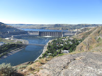
We visited and toured the Grand Coulee Dam, a true multipurpose structure. The dam controls what used to be the annual flooding of cities along the gorge, has the second largest hydroelectric generating capability in the world, and provides irrigation for over a million acres of fertile land now producing massive agricultural crops that used to be barren. When completed in 1941, the Grand Coulee Dam was both the largest construction project and the largest concrete structure in the world. In 2012, it was surpassed by the Three Gorges Dam on the Yangtze River in China. Interestingly, we have also been to that dam as well.

We learned that despite its achievement, the dam was not built without breaking some eggs – lots of eggs apparently. 14 towns and thousands of settler’s homesteads were submerged when the basin behind the dam filled. Sadly, despite the assurances that the federal government would assist everyone in their relocation, apparently little or none of that assistance actually came. In addition, at least a dozen sacred native burial sites are now under thousands of feet of water. Finally, the natives north of the dam were totally dependent on the abundant salmon both for food and as their primary trading medium. Sadly, despite trying to install fish ladders, it turns out the dam is too high, no salmon can spawn above it anymore, and the population of salmon in the Columbia River plummeted precipitously.
Every night the Bureau of Reclamation along with other government departments puts on a laser light show that covers the entire face of the dam. The show was technically well done and was very interesting to attend.
We wanted to visit Kettle Falls, one of the more famous of the submerged towns. However, it was some 65 miles upriver, and after doing some research, learned that there is really no way to visit the former town. There are some remnants that residents had relocated as the rising waters approached. However we decided that there might not have been enough compelling to warrant the 2 hour one way travel investment.
Talk to you soon!

Thursday, June 15, 2017

Dry falls


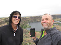
We visited Dry Falls in Washington. Apparently at the end of the Ice Age, glaciers blocked the otherwise normal flows of many rivers in the northwest causing an immense lake of stranded water. When the water broke, it resulted in a monumental wash of the NW US with raging waters that eroded cavernous terrain and produced geologic features that were not recognized as being created by the existence of water until current years.


dDry Falls is one of those features not recognized until the 20th century. Toward the end of the ice age, it saw 10 times the water flow that now graces Niagara Falls. 3 times as wide as Niagara and over 400 feet in height, the flow here, believed to have been upwards of 300 feet deep, would have dwarfed what is the greatest falls in North America.

This intense glacial flood created ripples across the north-western US that, from the ground level, just look like rolling hills. But once we had the perspective of seeing the NW US from space, it was clear that these features were ripples just like those created on the floors of oceans and the great lakes.
While no water flows over the edge today, the ripples and carved canyons (called “coulees” by scientists) remain as evidence. We enjoyed the visit and the history lesson.
Talk to you soon!

Tuesday, June 13, 2017

Friendliest city my a_s!


We’ve been traveling by motor home for some 10 years.  Before that, we camped in a travel trailer for 12 years with our kids.  Before that it was some 9 years in a tent trailer. Before that a tent and our instincts.

In all that 40 plus years of camping out we never experienced any crime. In Walla Walla, allegedly the friendliest city in the US, as we set up to head out, we found that the 3 packs, granted velcroid, not locked to our bikes, had been stolen. Not a great deal of money stolen, but the first time in our camping history that we had been violated.

The folks in Walla Walla may feel safe, but we ended up not feeling so much.

Talk to you soon!

Sunday, June 11, 2017

Who knew!

So, it turns out that there are over 180 wineries in the Walla Walla River valley and at the base of the nearby Blue Mountains. We were pleasantly surprised to learn this – it was clearly obvious as we drove into town seeing vineyards dotting the highway.

While we would not typically pony up the scratch for a winery tour – we would just visit some on our own – a visionary entrepreneur changed our mind. A year ago, Jim and his wife decided to make Walla Walla their ultimate retirement location after reading how it was the friendliest town in the US. Wanting to establish his own business here, he bought one of the very first Model S Tesla fully electric cars to be his vehicle for conducting winery tours. What a genius!
So, we couldn’t pass up the chance to be chauffeured while experiencing what Elon Musk has created. Jim escorted us for 4 hours to several vineyards, most of which their owners were actually manning the tasting rooms. While shuttling us around, Jim gave us some really nice insight into the Walla Walla area and what makes it such a vibrant destination. In addition, he made sure that we got a chance to see what the Model S Tesla could do. The entire package was so compelling!
Jim made sure we saw how all the electronics kept you safe and sound in this very versatile vehicle. Literally a mean sports car in an SUV body, Jim configured his Model S with 7-person seating – 2 front seats, 3 midsection seats, and two more in the rear. Looking at the vehicle when it arrived I could not believe he was able to accommodate 6 guests – until I got inside and saw the unbelievably smart, innovative use of space.
Then Jim started to show off. When we hit a downtown tasting room, he deliberately found a single parking space between two other parked cars. He took his hands off the steering wheel and the Model S, assuming he wanted to park, lined itself up against the car in front, and let him know on screen monitor that it was ready to park. He hit the park button, and the Model S expertly backed itself in. When we got out, it was precisely in the middle of the parking space, and perfectly aligned near but not touching the curb. Jim admitted that he was fully capable of such expert parking, but chooses not to!
In the last demo, Jim took us out on Highway 12. He let go of the wheel again and hit a button telling the Model S to stay a set distance behind the car in front. As that car changed speed, so did the Model S, keeping the space between constant. The Model S uses a combination of GPS and cameras that read lane markings to steer itself precisely centered in the lane. At some point, Jim turned on the left turn signal, which alerted the Model S that is was OK to pass the car it was following. The Model S changes lanes by itself, centering now in the left lane. The Model S accelerated to the speed that Jim had originally told it, passed the car, and then by itself, changed back into the right lane once clear of the passed vehicle, using turn signals appropriately.
If you are ever in Walla Walla, we strongly recommend you check out Jim at Teslawinetours.com.
Talk to you soon!

Friday, June 9, 2017

Historic Walla Walla

We were surprised to find a national historic site managed by the National Park Service in Walla Walla Washington. At Whitman Mission NHS we learned about a missionary family who predated the flow of pioneers into northern Oregon by over 5 years!

In 1835, the American Board of Foreign Missions sent Dr. Marcus Whitman and his wife Narcissa to the Oregon Country to select a mission site. Their mission was to convert the indigenous folk to Christianity and thereby, save them from eternal damnation. For over 5 years the Whitman’s only lived among the Cayuse tribe preaching the bible. The only other white Europeans they saw were trappers working for the Hudson’s Bay Company.
In 1841 American pioneers began to arrive from the east. Only 25 documented pioneers entered Oregon in 1841, 100 in 1842 and 800 in 1843. It wasn’t until the late 1840’s that the numbers became thousands per year. With those large numbers came the diseases that the white Europeans had built resistance to – small pox and others. The Cayuse saw that when whites contracted diseases, Dr. Whitman was able to cure them. But when the Cayuse contracted these diseases, they died.
In 1847 a particularly vicious strain of measles hit the area. Again, whites generally survived when treated by Dr. Whitman, but upwards of half the entire population of Cayuse died from this epidemic. Believing that Dr. Whitman was either not treating them the same as whites, or may even be poisoning them, on November 29 1847, a Cayuse party attacked the Mission killing the Whitman’s and 10 other pioneers who had holed up there for the winter.
The NHS is the site of the 1835 Mission. The original grave site where the Whitman’s and other pioneers killed in the massacre is on a hill overlooking the Mission site. No buildings are here, but the foundations of the original Mission buildings have been excavated so you can see and actually stand in the rooms where both Marcus and Narcissa Whitman’s dead bodies lay after the raid.
This was a very interesting site, and not one either of us had learned about in school.
We also visited the Frenchtown Historic Site. In the late 1840 with the arrival of thousands of pioneers, towns started to dot the Walla Walla River. This site was a town established primarily by French Canadians, and also ended up being the location of the Battle of Walla Walla, the longest battle with natives in the Oregon territory. This cabin was actually built in 1837, and is the oldest standing structure in the state.
Talk to you soon!

Wednesday, June 7, 2017

Shrunk!

Finally, after almost five months without a printer/scanner, HP has finally owned up to their obligation. The HP printer I bought in January was defective, and I have been trying to get it replaced ever since. HP does all they can to prevent their customers from being able to actually speak to someone, and when you finally can get either a web chat or even talk to someone live, that person is overseas and being able to arrange delivery details when you are moving from city to city every week is nearly impossible. We’ve had replacement printers delivered to RV parks on our behalf, only to have FedEx refuse to leave them as we weren’t there in person to sign for the delivery. Sadly, FedEx just sent them back to HP. To my great surprise and relief, the dude at the RV Park in Walla Walla was willing to accept the delivery and sign as though he was me – what a champion! HP has won the day and delivered the worst customer service I have ever experienced!

Next rant – one of my shoes actually shrunk! I was confused this morning when I put on my flip flops and realized that one of them didn’t fit any more – the left one was actually more than an inch shorter – smaller – than the right one! Somehow the Woman figured out what had happened. Last night we sat around the campfire, and it was a bit chilly so I got nice and close. I remember a couple of times getting up and noticing how hot the bottom of my shoe felt to my foot. Apparently, the close proximity to the campfire was enough to cause my shoe to actually shrink – amazing!
Talk to you soon!

Monday, June 5, 2017

Must return

Well, we thought we would be OK in Oregon in June. We were wrong. Everywhere we seem to go we are greeted by the same welcome sign – Road Closed!

Pretty much every Oregon Scenic Byway crosses a high elevation pass. And pretty much every one of them are still closed, even after Memorial Day. And they give you no warning whatsoever. I guess the locals know, but not us furiners. You just head up the highway and see how far you get before you hit the barriers.
So, we have to stick to the lower elevations. We wanted to head up into the Three Sisters Wilderness – three famous mountain peaks that were talked about in the writings from the mid-1800’s. We learned there were still glaciers gracing the Three Sisters peaks and were hoping to catch a glimpse or maybe even hike onto one, but no such luck.
We’ve gotten lucky even in the lower elevations. We discovered Whychus Creek – a water source and manageable entryway into the Three Sisters Wilderness. That is because the Creek is fed by the runoff of the glaciers up on the peaks. We could even see the greenish tint that signals glacial run off in the rapids of Whychus Creek. Even the pooch enjoyed the several milelong hike.
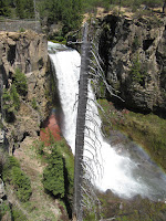
We found out way into Tumalo Falls on the western skirts of Bend. Tumalo is alleged to be the largest waterfall in central Oregon, and given the additional volume afforded by the still very active snow melt, the falls were spectacular.
We headed back to the Newberry Monument to venture up to the Newberry caldera. The caldera is so large that it contains two complete and separate lakes – East Lake and Paulina Lake. While most services were closed (yes, even after Memorial Day), we still enjoyed our visit and poking around.
A massive obsidian flow came from the Newberry caldera some 7,000 years ago. Obsidian is just like jet black glass, but it is raw rock sometimes created by volcanoes if the conditions are right. While the flow was mostly snow covered and the paths pretty much inaccessible, we were able to make it up the first set of stairs and get a great glimpse into this fascinating feature.
Paulina Lake fuels a fantastic waterfall near its perimeter. We were able to park outside the snowed in parking lot, and find a passable way down to the base of Paulina Falls. The hike was a little dicey due to the snow, but the view made it well worth it when we arrived. Luckily the way back up seemed a bit easier.
We also visited Lava River Cave. Named for the river of lava that created it – basically, a river of lava cools first on the outside creating a thick crust in the shape of a tube – the lava inside continues to flow through the tube. Eventually all the hot lava flows out, leaving this cave like structure. At some 10 miles long, this is the longest intact lava tube in Oregon. We hiked through the very rugged cave until we were content with our visit.
The town of Sisters is really fun – totally about visitors with quirky shops and restaurants/pubs. I personally like it more than Bend, although in Bend you get the benefit of more infrastructure. We didn’t know that “The Biggest Little Show in the World” is here. I wonder if the City of Reno knows that their trademark name has been taken hostage. We are heading out on 6/5, just a couple days before the big rodeo – dang!
We will have to return when we can do the Oregon Scenic Drives and venture into the Three Sisters Wilderness – maybe you can only be certain of access in July and August!
Talk to you soon!

Saturday, June 3, 2017

Newberry Volcanic National Monument

We stumbled on a gem of a National Monument we knew nothing about. Newberry Volcanic National Monument, designated by Bush senior in 1990, covers about 55,000 acres and lies about 10 miles north of Bend Oregon. The reason we didn’t know anything about it is that it is one of the few National Monuments that is managed by the Forest Service. While challenging, we’ve managed to discover all the Monuments managed by the BLM, but those managed by the Forest Service remain elusive.

Lava Butte is a very intact cinder cone that rises some 500 feet above the 9 square mile lava flow it created some 7,000 years ago. From the edge of the cinder cone you get an awesome panorama of the mostly baron lava plain below. We circled the rim of the cone in order to get a perspective of the immense flow from every angle.
Every volcanic site has some features that are familiar, but also each one has some unique features as well. We found the Lava Cast Forest to be fascinating. We had never seen these kinds of formations in any other volcanic site, and we’ve been to many.
Apparently at the time of an eruption there was an existing forest here. The flowing lava surrounded the tree trunks destroying the small trees, but the very large trees held up long enough for the lava to cool and harden. The trees have long since decayed and disappeared, but the casts that they formed in the cooling lava remain. You get a sense for the size of the tree based on the hole that was left.
We hiked through the lava flow as well. During the CCC era a trail was created that runs right through the center of the flow generated by Lava Butte. Once in the middle of the flow you are completely surrounded by the lava – it’s all you can see with the exception of the glorious peaks of the Cascade Mountain range.
If you are ever lucky enough to be in Bend, Newberry Volcanic National Monument should be a must see on your list.
Talk to you soon!

Thursday, June 1, 2017

Trade offs

First the bad. We continue to find access points to the Pacific Crest Trail nearby. However, most of the PCT in the higher elevations where we are still has several feet of snow covering both the trail and the surrounding forest. Other than a few feet of access to at least see the trail signage, the PCT is pretty much impassible here.

We have managed to find some access points at lower elevations so that the Woman can satisfy her PCT obsession at least a bit. We have managed to hike maybe 6-8 miles of the PCT in central Oregon but have encountered a strange experience. We know we are on the PCT as we have been guided here by experienced locals – locals who are trail angels and help the through hikers during the season. We also know we are on the PCT because the trail is on Google Maps – Google knows everything. When we have cell service, it’s easy to confirm that we are meandering along the PCT.
The strange experience? We walk for a couple miles at a time and never see a PCT blaze. There are many trails merging and splitting off from the one we are on, and we confirm with Google Maps that we are on the PCT itself. But still no blazes – not even where other trails merge. We were able to spot this blaze marking the Metolius-Windigo Horse Trail near the Whitehorse Horse Camp that shares the PCT in this area, but no official PCT blazes. This part of the PCT must be a real challenge for through hikers during the season.
Now the good news. All the snow melt has the local rivers completely full. The North Umpqua and South Umpqua rivers in the Cascade Mountain Range are loaded with beautiful waterfalls. Most require a bit of a hike from a parking area in order to see, but with the hip seeming to get a bit better, they’re not beyond our capability or interest. The guide books list 25 accessible waterfalls along the Umpqua, Little and Row rivers. Over a couple days we managed to hit 8 of them.
Each falls we hiked to was different. Some were cascading falls along a series of rock steps. Others were plunge falls descending vertically and losing contact with the rock surface in the fall. Susan Creek falls were a nice example of the cascading falls, labeled a fan falls because of its wide spray area caused by its massive flow.
Watson fall is totally a plunge fall. At nearly 300 feet it is the tallest falls in southwest Oregon and the third tallest in the state. We hiked up to its base, enjoying the numerous cascading falls leading up to the big plunge.
The falls along the North Umpqua River were our favorite. While it takes a bit of driving from any of the populated areas, the drives themselves are beautiful, and the falls just add a huge bonus to the beauty. And you get to stumble upon little gems like Tiller Oregon. Once a thriving community, the lack of jobs and services have led to an exodus of residents. What is left of the local city government is in the process of trying to unload all its buildings – the schools, the fire department, etc. Pretty sad when you think of the historical significance.
Talk to you soon!