 When the
Woman booked us for a week at this remote US Forest Service campground, I was a
bit nervous there would be a lot of idle time. It turned out I need not have
worried. We have been busy every day packing picnic lunches, heading out and
exploring this fascinating area.
When the
Woman booked us for a week at this remote US Forest Service campground, I was a
bit nervous there would be a lot of idle time. It turned out I need not have
worried. We have been busy every day packing picnic lunches, heading out and
exploring this fascinating area. We
visited and hiked the main trails at the Joyce Kilmer Memorial Forest. Kilmer,
born in 1886, was the poet who wrote the famous poem “I think that I shall
never see a poem lovely as a tree.” I don’t know the story about why his
parents decided to name him Joyce, but I do know that Johnny Cash apparently
was really breaking any new ground singing about a boy named Sue.
We
visited and hiked the main trails at the Joyce Kilmer Memorial Forest. Kilmer,
born in 1886, was the poet who wrote the famous poem “I think that I shall
never see a poem lovely as a tree.” I don’t know the story about why his
parents decided to name him Joyce, but I do know that Johnny Cash apparently
was really breaking any new ground singing about a boy named Sue. In 1975,
Congress dedicated this 17,394 acre forest to Kilmer primarily because of this
one poem. The memorial is a particularly dense old growth hard wood forest with
really massive trees – perhaps not quite as massive as the giant redwoods or
sequoia in California, but nearly so. The hike among them was peaceful and
almost religious in a way. In addition writing that famous poem, Kilmer was a
dedicated member of the US Army and actually was killed by a sniper in action in Europe in
1918. This forest seems a fitting tribute.
In 1975,
Congress dedicated this 17,394 acre forest to Kilmer primarily because of this
one poem. The memorial is a particularly dense old growth hard wood forest with
really massive trees – perhaps not quite as massive as the giant redwoods or
sequoia in California, but nearly so. The hike among them was peaceful and
almost religious in a way. In addition writing that famous poem, Kilmer was a
dedicated member of the US Army and actually was killed by a sniper in action in Europe in
1918. This forest seems a fitting tribute. We hike
into a waterfall pretty much every day. Because the terrain is so hilly and the
forest so lush, waterfalls seem to be everywhere, and pretty much all of them
have an established trail leading to a really nice viewpoint. Some take a
couple of miles of hiking to get to, but some only require an investment of a
half mile or so to claim your reward. Most days we try to get two waterfalls
under our belts. Waterfalls are something we just can’t get enough of.
We hike
into a waterfall pretty much every day. Because the terrain is so hilly and the
forest so lush, waterfalls seem to be everywhere, and pretty much all of them
have an established trail leading to a really nice viewpoint. Some take a
couple of miles of hiking to get to, but some only require an investment of a
half mile or so to claim your reward. Most days we try to get two waterfalls
under our belts. Waterfalls are something we just can’t get enough of. In the
small town of Robbinsville NC we learned about the Cherokee known as Junalaska.
Junalaska, born around 1775 in Franklin North Carolina, was not a Cherokee Chief,
but well known in the area for assisting white settlers in the area, teaching
them the ways of the land and assuring their successful settlement. Junalaska joined
the army and served valiantly in many of the Indian wars. Junalaska is even
credited with having saved the life of General Stonewall Jackson at the Battle
of Horseshoe Bend. Despite all this, when the Cherokee were gathered up in
accordance with the Indian Removal Act of 1830 and walked to Oklahoma in 1838,
Junalaska was not spared the ordeal of this nearly 900 mile death march. In 1910,
in honor of their valiant citizen, the Daughters of the American Revolution set
up this memorial to their comrade at the gravesite of Junalaska.
In the
small town of Robbinsville NC we learned about the Cherokee known as Junalaska.
Junalaska, born around 1775 in Franklin North Carolina, was not a Cherokee Chief,
but well known in the area for assisting white settlers in the area, teaching
them the ways of the land and assuring their successful settlement. Junalaska joined
the army and served valiantly in many of the Indian wars. Junalaska is even
credited with having saved the life of General Stonewall Jackson at the Battle
of Horseshoe Bend. Despite all this, when the Cherokee were gathered up in
accordance with the Indian Removal Act of 1830 and walked to Oklahoma in 1838,
Junalaska was not spared the ordeal of this nearly 900 mile death march. In 1910,
in honor of their valiant citizen, the Daughters of the American Revolution set
up this memorial to their comrade at the gravesite of Junalaska.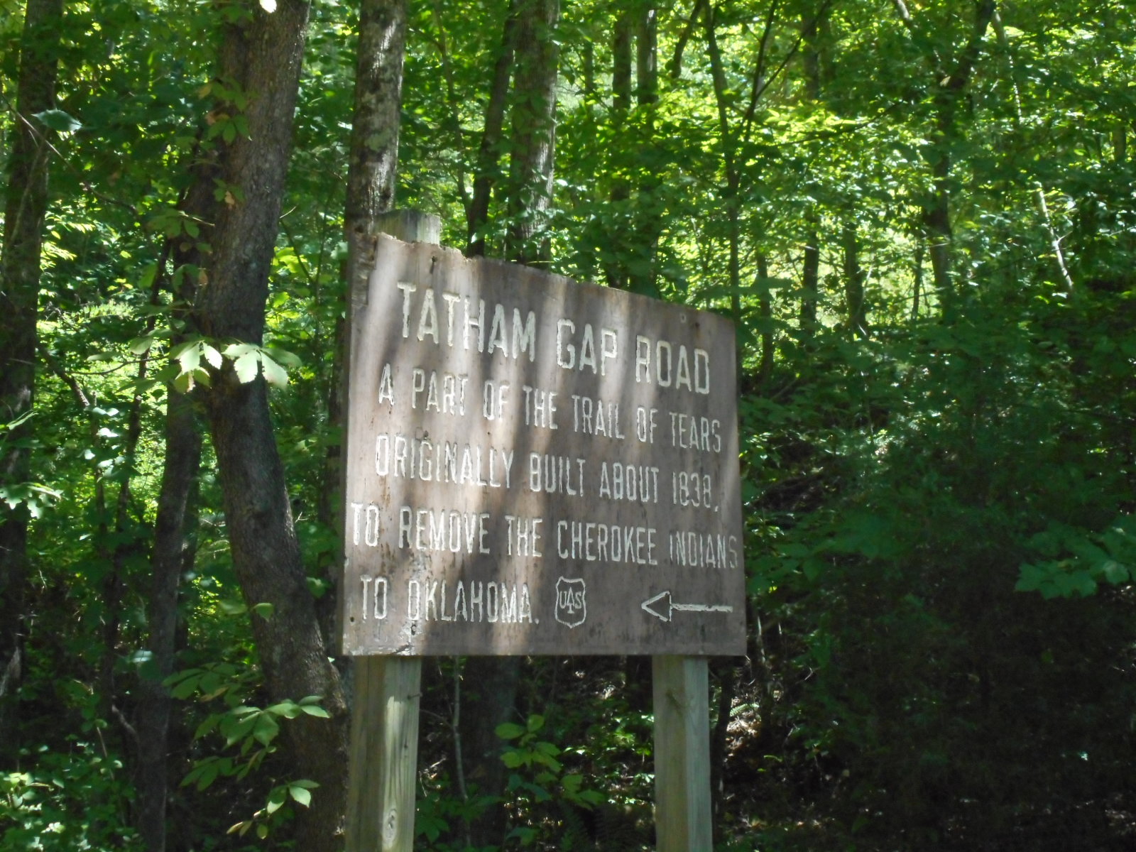 Just
outside Robbinsville is the start of the historic Cherokee Trail of Tears. It
follows an old Army road through Tatham Gap, and that section of the Trail
still exists much as it would have looked in 1838. We drove about 10 miles of
the original trail up and over the Gap. It would have been a grueling trek, and
we only saw about 10 miles of the total of 900 some odd miles the Cherokee
walked.
Just
outside Robbinsville is the start of the historic Cherokee Trail of Tears. It
follows an old Army road through Tatham Gap, and that section of the Trail
still exists much as it would have looked in 1838. We drove about 10 miles of
the original trail up and over the Gap. It would have been a grueling trek, and
we only saw about 10 miles of the total of 900 some odd miles the Cherokee
walked. Looks to
me that woodpeckers really like this kind of tree for some reason – what say
you?
Looks to
me that woodpeckers really like this kind of tree for some reason – what say
you? We have
managed another maybe 10 miles of Appalachian Trail in the hills of western
North Carolina. Any time the Woman can spend on the Appalachian Trail makes her
happy, so she has been plenty happy here for quite a bit.
We have
managed another maybe 10 miles of Appalachian Trail in the hills of western
North Carolina. Any time the Woman can spend on the Appalachian Trail makes her
happy, so she has been plenty happy here for quite a bit. One of
the sections along the Kephart Creek had this shelter. While there wasn’t
anyone bedded down here, that doesn’t mean that someone didn’t spend the night
here. This time of year is as high a traffic time on the Trail as any, Those
heading north are trying to make sure they get to Maine before the snow flies.
Most heading south have already passed through here.
One of
the sections along the Kephart Creek had this shelter. While there wasn’t
anyone bedded down here, that doesn’t mean that someone didn’t spend the night
here. This time of year is as high a traffic time on the Trail as any, Those
heading north are trying to make sure they get to Maine before the snow flies.
Most heading south have already passed through here. We have
managed to meet and chat with a few through hikers, but only a few. The Woman
reminds me that only somewhere around 5% of the folk who set out to do the
entire Trail actually end up accomplishing it. Given the terrain we have
encountered, I am not surprised.
We have
managed to meet and chat with a few through hikers, but only a few. The Woman
reminds me that only somewhere around 5% of the folk who set out to do the
entire Trail actually end up accomplishing it. Given the terrain we have
encountered, I am not surprised. I guess
the personalized license plate name “Packer backer” had already been taken. I
imagine this car gets trashed a bit when these folks are at home.
I guess
the personalized license plate name “Packer backer” had already been taken. I
imagine this car gets trashed a bit when these folks are at home.
When
hiking the portion of the Smoky Mountain National Park that sits in western
North Carolina, we came across some CCC era structures no longer in use, or
even trying to be maintained. We came across a rock cairn which used to be a
water fountain, an NPS stone sign that no longer informs what it was first
intended to let folk know, and this stone chimney from either a ranger quarters
or a visitor center. We have scoured the Park literature, but have yet to
determine what these ruins were originally used for.
 The
eastern entrance to Smoky Mountain National Park is in the town of Cherokee on
the Cherokee reservation. Cherokee is also the start of the 470 mile long Blue
Ridge Parkway, which we drove on a bunch when we visited Ashville last fall.
The
eastern entrance to Smoky Mountain National Park is in the town of Cherokee on
the Cherokee reservation. Cherokee is also the start of the 470 mile long Blue
Ridge Parkway, which we drove on a bunch when we visited Ashville last fall. We
decided to venture in 20 miles to visit one of the many visitor centers on the
Parkway. It was a nice center, and had a nice balcony with tree branch rocking
chairs that totally reminded us of the ones on the North Rim of the Grand
Canyon at the historic lodge. Time for a break!
We
decided to venture in 20 miles to visit one of the many visitor centers on the
Parkway. It was a nice center, and had a nice balcony with tree branch rocking
chairs that totally reminded us of the ones on the North Rim of the Grand
Canyon at the historic lodge. Time for a break! The Park
Service is happy about the reintroduction in 2002 of Elk to the Great Smoky
Mountains. After being absent for perhaps a century, the herds have returned to
much local joy. While they aren’t as plentiful here on the eastern end of the
Park as they were in Cades Cove, we managed to catch a glimpse from the car as
we scooted by this majestic resting couple.
The Park
Service is happy about the reintroduction in 2002 of Elk to the Great Smoky
Mountains. After being absent for perhaps a century, the herds have returned to
much local joy. While they aren’t as plentiful here on the eastern end of the
Park as they were in Cades Cove, we managed to catch a glimpse from the car as
we scooted by this majestic resting couple.


