 Well, the
first day post-surgery was a little tame. We checked out the visitor center,
watched a couple of movies, did some short nature trails and did some
geocaching. Robin was in quite a bit of pain, so didn’t really want to push it
too much.
Well, the
first day post-surgery was a little tame. We checked out the visitor center,
watched a couple of movies, did some short nature trails and did some
geocaching. Robin was in quite a bit of pain, so didn’t really want to push it
too much.
But the
next day we tackled the Palm Canyon hike. It was rated as an easy hike, but
after getting along up the trail a bit, we found out that a fair bit of rock
scrambling was required. At first, Robin was inclined to turn around, but I
told her she could use my shoulder, or we would walk hand in hand if needed so
that she could get over the occasional scrambling. As it turned out, she nearly
made it to standing in the midst of the palm grove – maybe about 100 yards shy
– the last 100 yards or so required one to cross the stream twice, stepping on
rocks that moved as you went. She could see all she wanted of the actual grove,
and was happy just to have handled the mile and a half in. I was impressed.
 The next
day, the first of our two hikes was a ba!! buster. Back in the 1930’s, the US
military used calcite in the manufacture of gun sights for its air fleet.
Calcite was hard to find. At the top of a mountain, in what is now the Northern
edge of Anza Borrego, a significant vein of calcite was discovered. To meet the
needs of the military, the veins were strip mined until 1945 when an artificial
substance was discovered to take the place of calcite in bomb sights. During
the time it was mined, the Polaroid Company managed the mining operations.
The next
day, the first of our two hikes was a ba!! buster. Back in the 1930’s, the US
military used calcite in the manufacture of gun sights for its air fleet.
Calcite was hard to find. At the top of a mountain, in what is now the Northern
edge of Anza Borrego, a significant vein of calcite was discovered. To meet the
needs of the military, the veins were strip mined until 1945 when an artificial
substance was discovered to take the place of calcite in bomb sights. During
the time it was mined, the Polaroid Company managed the mining operations. The mine
was 2 miles in from highway – and about 1500 feet up! The hiking trail actually
followed the old mining road that was used to get the ore down from the mine
back in the days. The trail was not only steep, but had a lot of loose rock and
sand – and the sun was blisteringly hot! But the Woman persevered, and made it
all the way. What a champion – even those in the group that had the use of both
arms for balance and were not wearing a hot, black sling were weary by the end
of that hike.
The mine
was 2 miles in from highway – and about 1500 feet up! The hiking trail actually
followed the old mining road that was used to get the ore down from the mine
back in the days. The trail was not only steep, but had a lot of loose rock and
sand – and the sun was blisteringly hot! But the Woman persevered, and made it
all the way. What a champion – even those in the group that had the use of both
arms for balance and were not wearing a hot, black sling were weary by the end
of that hike. We
decided to let the heat of the day pass a bit, and let the sun angle drop a bit
before tackling the next hike. We hiked the Palm Slot Canyon Trail. The trail
followed the wash through some of the narrowest canyon walls we have seen in a
while. Again, Robin was required to scramble up and down some rocks, and this
is when the patented butt slide maneuver was invented. When the slot got too
narrow for the Woman to get footing without risking bumping her arm in the
sling, she would just sit on the slanted rock, working her feet through and
sliding her butt as she did. The move really did work well.
We
decided to let the heat of the day pass a bit, and let the sun angle drop a bit
before tackling the next hike. We hiked the Palm Slot Canyon Trail. The trail
followed the wash through some of the narrowest canyon walls we have seen in a
while. Again, Robin was required to scramble up and down some rocks, and this
is when the patented butt slide maneuver was invented. When the slot got too
narrow for the Woman to get footing without risking bumping her arm in the
sling, she would just sit on the slanted rock, working her feet through and
sliding her butt as she did. The move really did work well. We had
maybe hiked a couple of miles when we hit a rock wall that would require a four
or five foot climb to get over. That was when Robin decided that maybe a couple
miles of slot canyon was sufficient. Ron and Teresa forged ahead a bit, but
then came back and said they agreed that it might be a good time to head back –
apparently the canyon above the wall widened back out and was not nearly as
pretty as what we had been hiking through. So we headed back through what was
now the fully shaded canyon, getting a difference glimpse of its wonders.
We had
maybe hiked a couple of miles when we hit a rock wall that would require a four
or five foot climb to get over. That was when Robin decided that maybe a couple
miles of slot canyon was sufficient. Ron and Teresa forged ahead a bit, but
then came back and said they agreed that it might be a good time to head back –
apparently the canyon above the wall widened back out and was not nearly as
pretty as what we had been hiking through. So we headed back through what was
now the fully shaded canyon, getting a difference glimpse of its wonders.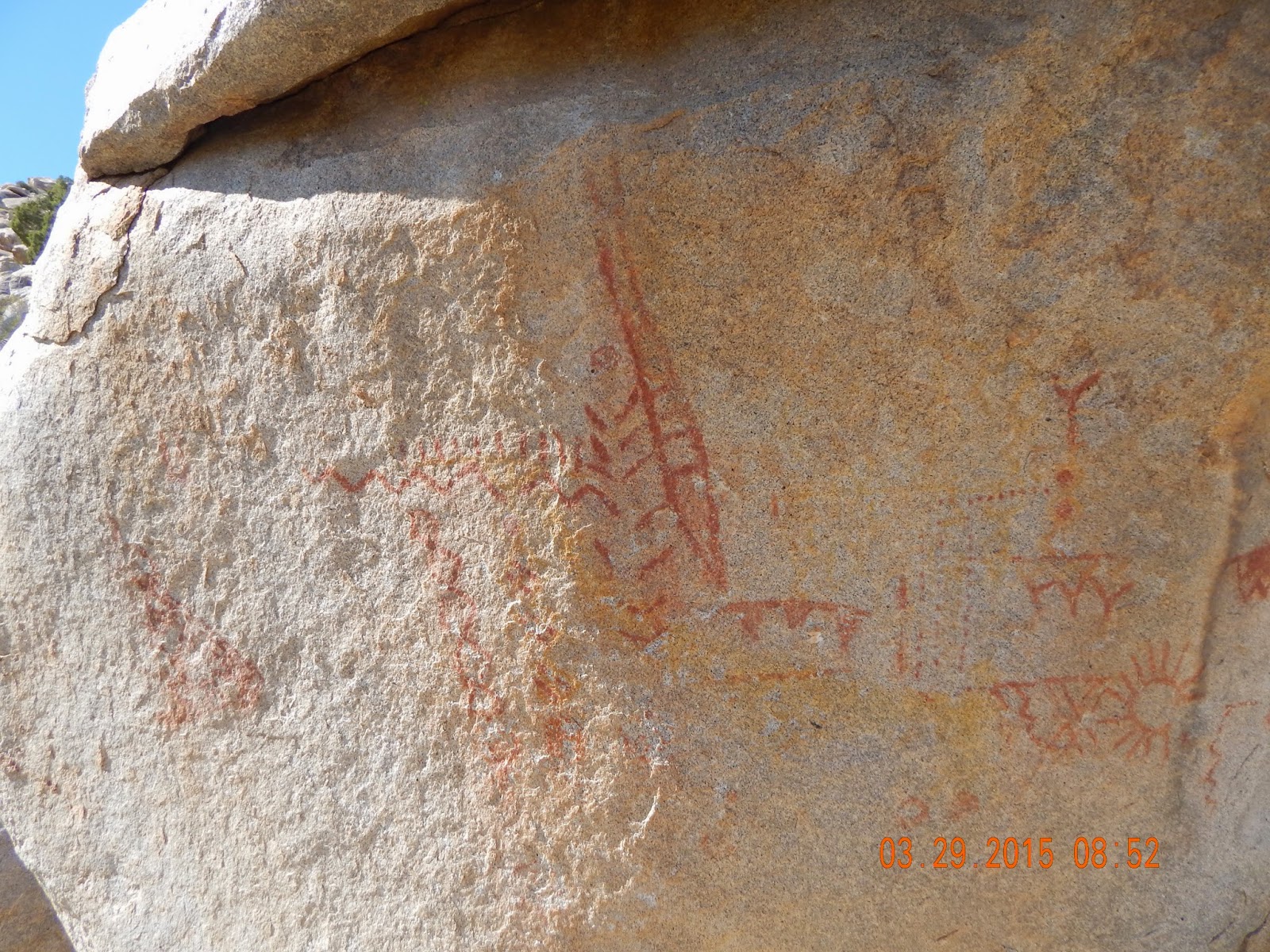 But the
next day the Woman rocked! Our first hike was 2 miles in, then back. At 1 ½
miles in there was a huge boulder with a considerable number of pictographs on
it. Scientists believe they were left by the Kumeyaay or Agave people. They are
not certain just how old they are, but believe the Kumeyaay occupied these
lands over 2,000 years ago. This find alone was worth the hike.
But the
next day the Woman rocked! Our first hike was 2 miles in, then back. At 1 ½
miles in there was a huge boulder with a considerable number of pictographs on
it. Scientists believe they were left by the Kumeyaay or Agave people. They are
not certain just how old they are, but believe the Kumeyaay occupied these
lands over 2,000 years ago. This find alone was worth the hike.
We
continued on the last half mile and came to Smuggler’s Canyon. As we approached
what seemed to be back of a large enclosed corral formed by the canyon walls,
we realized that there was a narrow slot that made its w
 ay through the very
back. As we made our way back, we found ourselves on the top of a sheer wall
with at least a hundred foot drop – you could see the water stains all over the
precipice from when the spring melts come cruising down and over this edge. It
must be pretty spectacular when the water comes flying through.
ay through the very
back. As we made our way back, we found ourselves on the top of a sheer wall
with at least a hundred foot drop – you could see the water stains all over the
precipice from when the spring melts come cruising down and over this edge. It
must be pretty spectacular when the water comes flying through.
The view
of the entire valley was wonderful from this vantage point. We weren’t exactly
sure what direction we were looking, but it was so splendid, we didn’t really
care. Little did we know that we would be looking out over the area of our
third hike of the day.
 On our
way back from Smuggler’s Canyon, we stopped to say goodbye to the amazing
pictographs. A German couple that we had seen in the Canyon were there poking
around, and asked if we wanted to see the rattlesnake – to which we said “Sure!”
Well, when they showed us where the snake was curled up under the edge of a
boulder, Ron realized that he had been standing next to that exact spot
admiring the pictographs on the way down. Good thing the rattler couldn’t be
bothered to strike!
On our
way back from Smuggler’s Canyon, we stopped to say goodbye to the amazing
pictographs. A German couple that we had seen in the Canyon were there poking
around, and asked if we wanted to see the rattlesnake – to which we said “Sure!”
Well, when they showed us where the snake was curled up under the edge of a
boulder, Ron realized that he had been standing next to that exact spot
admiring the pictographs on the way down. Good thing the rattler couldn’t be
bothered to strike! The next
hike was short – maybe a mile in. Apparently the Kumeyaay lived throughout the
area, and this particular canyon they found dwelling. Evidence of food storage
and food preparation is scattered throughout the canyon. Rock dwellings likely
inhabited by the Kumeyaay were everywhere you looked. And near each of the
likely dwellings were grinding pits – knows by the folk of the day as Morteros –
essentially mortars carved by sheer force in the surface of a smooth stone.
Sometimes there were multiple grinding pits on the same stone surface –
indicating large scale food preparation going on at some point in the distant
past. Scientists believe the Kumeyaay used these areas over 2,000 years ago!
The next
hike was short – maybe a mile in. Apparently the Kumeyaay lived throughout the
area, and this particular canyon they found dwelling. Evidence of food storage
and food preparation is scattered throughout the canyon. Rock dwellings likely
inhabited by the Kumeyaay were everywhere you looked. And near each of the
likely dwellings were grinding pits – knows by the folk of the day as Morteros –
essentially mortars carved by sheer force in the surface of a smooth stone.
Sometimes there were multiple grinding pits on the same stone surface –
indicating large scale food preparation going on at some point in the distant
past. Scientists believe the Kumeyaay used these areas over 2,000 years ago!
Our third
hike of the day was only two miles round trip, but was certainly the hardest. Back
in the 1930’s during the depression, a renaissance man, born Roy Bennet
Richards in 1889 in Australia, could not find employment. In 1930, he and his
wife, Tanya, found this area formerly inhabited by the Kumeyaay to their
liking. They checked out the entire region, and when they found this spot on
the top of the Ghost Mountain, they decided that was where they were going to
live. Over time, they built a house, hauling all the material necessary up the
steep 1 mile hike from the closest spot to Ghost Mountain where they could get
their Model T Ford.
 When
completed, the Roy and Tanya named their haven Yaquitepec. They lived here for
nearly 20 years. During that time, Roy would hike down Ghost Mountain and drive
the slow 20 some odd miles to Julian, a quaint mining town (an artist haven now
that is worth a visit), to get supplies and pick up their mail. Then all he had
gathered had to be hauled up the one mile climb to the home. Early on Roy
hauled up water he supplied from Julian – later they built a system of
collectors and storage tanks to nearly eliminate their need for outside water.
When
completed, the Roy and Tanya named their haven Yaquitepec. They lived here for
nearly 20 years. During that time, Roy would hike down Ghost Mountain and drive
the slow 20 some odd miles to Julian, a quaint mining town (an artist haven now
that is worth a visit), to get supplies and pick up their mail. Then all he had
gathered had to be hauled up the one mile climb to the home. Early on Roy
hauled up water he supplied from Julian – later they built a system of
collectors and storage tanks to nearly eliminate their need for outside water. During
that time, Roy and Tanya sired 3 children, Rider (1934), Rudyard (1937) and
Victoria (1940). The children were raised at Yaquitepec and educated by their
parents. When Roy would venture monthly into Julian for supplies, the children
would haul them up to the house. Tanya and the children only ventured into
Julian every six months or so, and never formally attended school. To make
money to buy supplies, Roy wrote poetry and articles about he and Tanya’s
elegant experiment on Ghost Mountain, much of which appeared in the Saturday
Evening Post and other popular papers of the time. To make his writing seem
more poetic and mysterious, he assumed the nom de plume of Marshall South.
Eventually, Marshall began spending more time in Julian than he did at
Yaquitepec, Tanya tired of the hard life, and Tanya left Yaquitepec with her
children and divorced Marshall. All 3 children ended up having very successful
lives.
During
that time, Roy and Tanya sired 3 children, Rider (1934), Rudyard (1937) and
Victoria (1940). The children were raised at Yaquitepec and educated by their
parents. When Roy would venture monthly into Julian for supplies, the children
would haul them up to the house. Tanya and the children only ventured into
Julian every six months or so, and never formally attended school. To make
money to buy supplies, Roy wrote poetry and articles about he and Tanya’s
elegant experiment on Ghost Mountain, much of which appeared in the Saturday
Evening Post and other popular papers of the time. To make his writing seem
more poetic and mysterious, he assumed the nom de plume of Marshall South.
Eventually, Marshall began spending more time in Julian than he did at
Yaquitepec, Tanya tired of the hard life, and Tanya left Yaquitepec with her
children and divorced Marshall. All 3 children ended up having very successful
lives. What is
left of the home still sits atop Ghost Mountain. As we came to a flat area in
the ascent, we thought we had gone maybe ¾ of the way, and saw where we likely
needed to end up, already just a tad weary of the climb. But lo and behold,
only a few steps later and we saw the house – just a doorway frame and some
crumbling adobe walls. It won’t be that many more years before the Mountain
reclaims the land that the South’s lived on and the home they lived in.
What is
left of the home still sits atop Ghost Mountain. As we came to a flat area in
the ascent, we thought we had gone maybe ¾ of the way, and saw where we likely
needed to end up, already just a tad weary of the climb. But lo and behold,
only a few steps later and we saw the house – just a doorway frame and some
crumbling adobe walls. It won’t be that many more years before the Mountain
reclaims the land that the South’s lived on and the home they lived in.
We could
still see their water gathering and storage system. Rather than the adobe used
to build the house which will eventually melt back into the Mountain, the water
system was built using the concrete that Marshall and the family hauled up from
the Model T. It will be a much longer time before the evidence of this part of
their lives is completely erased.
 The hike
was good, although the most of the scrambling of any of the hiking we had done
in Anza Borrego. We enjoyed the reward of Yaquitepec, the rusting box spring,
the clearly evident stove and fireplace remains, and especially the views. From
the areas just steps from the South’s door front, the entirety of the valley
lies below. It is really dramatic.
The hike
was good, although the most of the scrambling of any of the hiking we had done
in Anza Borrego. We enjoyed the reward of Yaquitepec, the rusting box spring,
the clearly evident stove and fireplace remains, and especially the views. From
the areas just steps from the South’s door front, the entirety of the valley
lies below. It is really dramatic. All in
all our visit to Anza Borrego was a great success. The name Anza Borrego comes
from the Spanish explorer de Anza who first explored this area in the 1700’s.
Borrego means lamb in Spanish, referring to the baby big horn sheep that dot
the area in the spring. While we did see all kinds of wild flowers and animal
life, we got shut out on the big horn sheep. We will have to come back some day
and try again.
All in
all our visit to Anza Borrego was a great success. The name Anza Borrego comes
from the Spanish explorer de Anza who first explored this area in the 1700’s.
Borrego means lamb in Spanish, referring to the baby big horn sheep that dot
the area in the spring. While we did see all kinds of wild flowers and animal
life, we got shut out on the big horn sheep. We will have to come back some day
and try again.
One last
tidbit of local lore caught our attention while we were having fun geocaching.
We had driving Peg leg Road and had no idea how it got its name. Well, Thomas
L. “Pegleg” Smith was a prospector, story teller, and general conman in the
area during the latter part of his life from 1801 to 1860. He reveled in
telling all that would listen that he had discovered a massive gold strike in
the area. The problem was that in his old age, his memory was failing him, and
he could not remember where the mine was that contained all his wealth.
 Apparently
the story caught on and people did come to the Borrego valley, not really to
prospect but rather to search for Pegleg’s mine. While people have speculated
over the decades that it is likely relatively close to the site of the
monument, nobody really knows – and nobody has found it!
Apparently
the story caught on and people did come to the Borrego valley, not really to
prospect but rather to search for Pegleg’s mine. While people have speculated
over the decades that it is likely relatively close to the site of the
monument, nobody really knows – and nobody has found it!
Well,
tomorrow is the Woman’s follow up surgeon appointment back in Palm Springs. I
guess I will wait to see is he thinks things look like they are healing well
before I mention to him the 30 some odd miles of rock scrambling she has been
doing.
Talk to
you soon!

No comments:
Post a Comment