 Grants
was settled soon after the Civil War both for mining and transportation
reasons. Minerals in the area attracted the attention of miners, and the laying
of the railroad lines essentially along the corridor for I-40 made Grants an
obvious candidate as a rail hub. Originally the town was called Grants Camp in
the 1880’s because 3 Canadian brothers, Angus, John and Lewis Grant, were
awarded a contract to build a section of the Atlantic and Pacific Railroad. The
name was changed to Grants Station, and ultimately just Grants. After the low
grade minerals were no longer economical to mine in the area, focus turned to
the lumber industry due to the nearby Cibola National Forest.
Grants
was settled soon after the Civil War both for mining and transportation
reasons. Minerals in the area attracted the attention of miners, and the laying
of the railroad lines essentially along the corridor for I-40 made Grants an
obvious candidate as a rail hub. Originally the town was called Grants Camp in
the 1880’s because 3 Canadian brothers, Angus, John and Lewis Grant, were
awarded a contract to build a section of the Atlantic and Pacific Railroad. The
name was changed to Grants Station, and ultimately just Grants. After the low
grade minerals were no longer economical to mine in the area, focus turned to
the lumber industry due to the nearby Cibola National Forest. In the
1930’s lumbering petered out, the recently created Bluewater Reservoir brought
new live to the town. It turned out the regions volcanic soils coupled with the
adjacent sandstone, when adding the new irrigation possibilities provided by
the reservoir made Grants the Carrot Capital of the US. The later development
of Route 66 (which Grants was on) and an airway beacon for commercial flight
that was located here resulted in new life each time the town was on the verge
of dying.
In the
1930’s lumbering petered out, the recently created Bluewater Reservoir brought
new live to the town. It turned out the regions volcanic soils coupled with the
adjacent sandstone, when adding the new irrigation possibilities provided by
the reservoir made Grants the Carrot Capital of the US. The later development
of Route 66 (which Grants was on) and an airway beacon for commercial flight
that was located here resulted in new life each time the town was on the verge
of dying. The most
memorable boom in Grants occurred in 1950 when Paddy Martinez, a local Native
American, discovered Uranium ore in the area. Apparently Martinez had surveyed
all the area around Grants and had a very good memory. While overhearing a
conversation among geologists who had visited Grants in search of ore deposits,
Paddy readily recognized the ore they were describing, and returned to Haystack
Mesa where he discovered the first major claim. Other mines in the area soon
emerged, and this Uranium mining boom lasted into the 1980’s, when the market
price of Uranium sunk to a point where it was no longer profitable to mine
here. We visited the Grants Chamber of Commerce offices which have built a
replica of a typical Uranium mine from the boom days in their basement. The
authentic displays of actual artifacts from the local mines, coupled with
recorded narration from mine workers, is a compelling and effective
presentation, well worth the time and small fee.
The most
memorable boom in Grants occurred in 1950 when Paddy Martinez, a local Native
American, discovered Uranium ore in the area. Apparently Martinez had surveyed
all the area around Grants and had a very good memory. While overhearing a
conversation among geologists who had visited Grants in search of ore deposits,
Paddy readily recognized the ore they were describing, and returned to Haystack
Mesa where he discovered the first major claim. Other mines in the area soon
emerged, and this Uranium mining boom lasted into the 1980’s, when the market
price of Uranium sunk to a point where it was no longer profitable to mine
here. We visited the Grants Chamber of Commerce offices which have built a
replica of a typical Uranium mine from the boom days in their basement. The
authentic displays of actual artifacts from the local mines, coupled with
recorded narration from mine workers, is a compelling and effective
presentation, well worth the time and small fee. The other
big surprise for us was El Malpais National Monument. Years ago we had visited
El Morro National Monument to see the famous Inscription Rock which has
signatures by visitors dating back to the Spanish Conquistadores. Even at that
time El Malpais was a National Monument, but because it was not managed by the
National Park Service it did not have as much visibility, and we missed it even
though it was only 30 or so miles away.
The other
big surprise for us was El Malpais National Monument. Years ago we had visited
El Morro National Monument to see the famous Inscription Rock which has
signatures by visitors dating back to the Spanish Conquistadores. Even at that
time El Malpais was a National Monument, but because it was not managed by the
National Park Service it did not have as much visibility, and we missed it even
though it was only 30 or so miles away. El
Malpais is another of the volcanic parks that have been designated as National
Parks and National Monuments, but it’s in a place where you might not have
expected this level of ancient volcanic activity. The lava flows here are extensive with lava
tube systems stretching over 17 miles, but the flows are only 2,000 to 3,000
years old. In geologic terms, this is really young.
El
Malpais is another of the volcanic parks that have been designated as National
Parks and National Monuments, but it’s in a place where you might not have
expected this level of ancient volcanic activity. The lava flows here are extensive with lava
tube systems stretching over 17 miles, but the flows are only 2,000 to 3,000
years old. In geologic terms, this is really young. The most
interesting part is that because it is mostly managed by the BLM, there are not
massive services available. In a volcanic National Park, there would likely be
ranger led tours into the lava tubes, but here, you obtain a caving permit, and
you are on your own to explore any of the lava tubes you want to.
The most
interesting part is that because it is mostly managed by the BLM, there are not
massive services available. In a volcanic National Park, there would likely be
ranger led tours into the lava tubes, but here, you obtain a caving permit, and
you are on your own to explore any of the lava tubes you want to.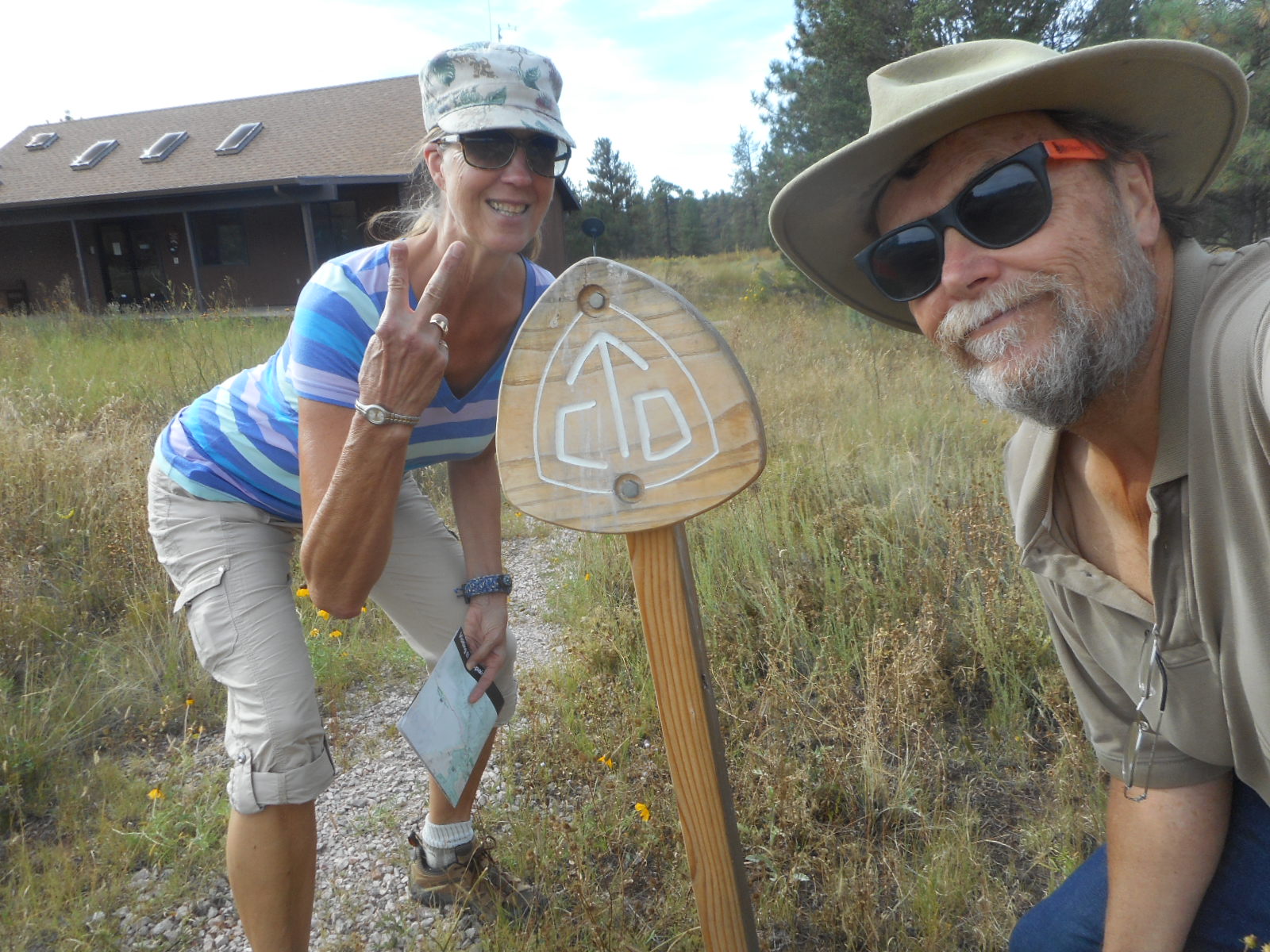 We stopped at the ranger station for some advice, and got the worst ever! The Ranger looked out the window at the Saturn and she said "I strongly recommend you don't go out to the lava tube area in that - your tires are too thin and you don't have enough clearance. I would also be afraid that you would break your bike rack hanging on the back on the horribly rough road. Last week a guy went out there with a low clearance vehicle and his bearings broke - he had to be towed out." Well, that is just the kind of talk to inspire the Woman. Assuming our plans were out of the question she started saying things like "Maybe we can rent a jeep somewhere around here to be able to get in." And she almost had me thinking about that seriously when I snapped out of it and said "Well, maybe we will do that, but not after we get a chance to see what the road is like for ourselves." After 10 or 15 minutes of mostly ho-hum driving (I did have to watch closely for holes and ruts) we pulled into the parking lot for the Big Tubes. I took a look and the bikes were somehow still there!
 The major
location of the lava tubes more easily reached in the Monument is called the Big
Tubes area. Unfortunately this area contains mostly Ah Ah lave – extremely
sharp and jagged – as opposed to Pahoehoe lave, which is a bit smother with
ridges and flows. Our friend Vern Bieraugel who lives in Kona Hawaii always
said they called this kind of lava Ah Ah because that what anyone would scream
who walked on it! While the Woman had no interest at all in entering the caves,
I put on my jeans, my hikers, grabbed a flashlight as well as my headlamp, and
I was ready to have at it. While I only explored a few of the caves, at least
the ones I didn’t have to crawl through (even though I brought kneepads, I
decided it was a bad idea), I still got enough to satisfy my curiosity. While
Monument information indicated that bats lived in the caves, I didn’t happen
upon any in by visits.
The major
location of the lava tubes more easily reached in the Monument is called the Big
Tubes area. Unfortunately this area contains mostly Ah Ah lave – extremely
sharp and jagged – as opposed to Pahoehoe lave, which is a bit smother with
ridges and flows. Our friend Vern Bieraugel who lives in Kona Hawaii always
said they called this kind of lava Ah Ah because that what anyone would scream
who walked on it! While the Woman had no interest at all in entering the caves,
I put on my jeans, my hikers, grabbed a flashlight as well as my headlamp, and
I was ready to have at it. While I only explored a few of the caves, at least
the ones I didn’t have to crawl through (even though I brought kneepads, I
decided it was a bad idea), I still got enough to satisfy my curiosity. While
Monument information indicated that bats lived in the caves, I didn’t happen
upon any in by visits. The Woman
was quite excited to learn that the Continental Divide Trail not only went
right through the middle of El Malpais National Monument, but it also went
right through the middle of Grants New Mexico. In the middle of the monument is
the Zuni-Acoma Trail, and ancient Native American route used by Zuni and Acoma
to cross these massive lava flows. We hiked in from both ends of the trail –
one is on NM 117 on the east edge of the Monument, and the other is on NM 53 on
the western edge. The CDT follows NM 53 along the western edge of the Monument,
then across the lava flows on the Zuni-Acoma Trail, and then runs north along
NM 117 until it reaches the eastern edge of Grants.
The Woman
was quite excited to learn that the Continental Divide Trail not only went
right through the middle of El Malpais National Monument, but it also went
right through the middle of Grants New Mexico. In the middle of the monument is
the Zuni-Acoma Trail, and ancient Native American route used by Zuni and Acoma
to cross these massive lava flows. We hiked in from both ends of the trail –
one is on NM 117 on the east edge of the Monument, and the other is on NM 53 on
the western edge. The CDT follows NM 53 along the western edge of the Monument,
then across the lava flows on the Zuni-Acoma Trail, and then runs north along
NM 117 until it reaches the eastern edge of Grants. Once it
hits Grants, the CDT follows old Route 66 to the center of town, then heads
north again along NM 457 on its way to Mount Taylor, one of the highest peaks
in New Mexico. We followed the CDT north out of town along NM 457 until it left
the highway and started its assent right up to Mount Taylor on US Forest
Service land. We hiked up a bit, but given the heat and altitude and all the
hiking we had done earlier, this particular leg of the CDT was pretty short.
Once it
hits Grants, the CDT follows old Route 66 to the center of town, then heads
north again along NM 457 on its way to Mount Taylor, one of the highest peaks
in New Mexico. We followed the CDT north out of town along NM 457 until it left
the highway and started its assent right up to Mount Taylor on US Forest
Service land. We hiked up a bit, but given the heat and altitude and all the
hiking we had done earlier, this particular leg of the CDT was pretty short. The
eastern edge of the Monument shows how the lava found the low land next to the
higher Sandstone Bluffs area that provide spectacular views of the massive lava
flows. While enjoying climbing on the immense bluffs and taking in the views,
we discovered the long abandoned Garrett Homestead. Like we had seen in other
remote areas, this home was built near the end of the Great Depression using
recycled materials. The family gathered already cut stone from abandoned Anasazi
dwellings and built themselves a rather comfortable home. Maybe this was one of
the original Earthships in New Mexico!
The
eastern edge of the Monument shows how the lava found the low land next to the
higher Sandstone Bluffs area that provide spectacular views of the massive lava
flows. While enjoying climbing on the immense bluffs and taking in the views,
we discovered the long abandoned Garrett Homestead. Like we had seen in other
remote areas, this home was built near the end of the Great Depression using
recycled materials. The family gathered already cut stone from abandoned Anasazi
dwellings and built themselves a rather comfortable home. Maybe this was one of
the original Earthships in New Mexico! South of the Sandstone Bluffs along NM 117, the El Malpais National Monument lava flows on the east
run right up against a 500-600 foot tall sandstone wall called the Narrows
Ridge that runs for miles. Smack in the middle of that wall is one of the
largest stone arches in New Mexico, La Ventana. Spanish for “The Window”, this
was a really impressive feature that we could nearly drive right to, so we
weren’t going to pass it up for anything. While we weren’t able to get up close
and personal – couldn’t touch it for example, but we were able to get close
enough to feel we were there.
South of the Sandstone Bluffs along NM 117, the El Malpais National Monument lava flows on the east
run right up against a 500-600 foot tall sandstone wall called the Narrows
Ridge that runs for miles. Smack in the middle of that wall is one of the
largest stone arches in New Mexico, La Ventana. Spanish for “The Window”, this
was a really impressive feature that we could nearly drive right to, so we
weren’t going to pass it up for anything. While we weren’t able to get up close
and personal – couldn’t touch it for example, but we were able to get close
enough to feel we were there. But, I
wasn’t ready to be done with La Ventana. 4 miles to the South along NM Highway
117 was the beginning of the Narrows Ridge. There was a nice picnic area there
where we had a nice lunch, and then I talked the Woman into setting out on the
Narrows Ridge Trail. It seemed more of a challenge than trails we had been
doing lately – 8 miles round trip and an elevation gain of around 600 feet. But
when the trail ended, you would find yourself at the La Ventana overlook – a natural
stone viewing platform high above the arch.
But, I
wasn’t ready to be done with La Ventana. 4 miles to the South along NM Highway
117 was the beginning of the Narrows Ridge. There was a nice picnic area there
where we had a nice lunch, and then I talked the Woman into setting out on the
Narrows Ridge Trail. It seemed more of a challenge than trails we had been
doing lately – 8 miles round trip and an elevation gain of around 600 feet. But
when the trail ended, you would find yourself at the La Ventana overlook – a natural
stone viewing platform high above the arch. We
started out on the trail with both enthusiasm and optimism. The trail ran all
along the edge of the Narrows Ridge, so you always had great views of the vast
lava flows in El Malpais National Monument. But it was both hot and sunny and
not much for shade. So, with the elevation gain pretty continuous on the way to
the overlook, the going was harder than I thought. When we finally reached a
big rock with “2.0 M” painted on it, the Woman said “if we are only halfway
there, I don’t think I can do this!” I told her I would like to give it a go,
and she said “well, we can try a little further.” I said “if we are just going
to hike another mile and turn around, I would rather just turn around now. The
only reason to continue now would be to try to get to the overlook. If we have
to bail, then we have to bail, but I don’t just want to walk a little further
and plan to turn around.”
We
started out on the trail with both enthusiasm and optimism. The trail ran all
along the edge of the Narrows Ridge, so you always had great views of the vast
lava flows in El Malpais National Monument. But it was both hot and sunny and
not much for shade. So, with the elevation gain pretty continuous on the way to
the overlook, the going was harder than I thought. When we finally reached a
big rock with “2.0 M” painted on it, the Woman said “if we are only halfway
there, I don’t think I can do this!” I told her I would like to give it a go,
and she said “well, we can try a little further.” I said “if we are just going
to hike another mile and turn around, I would rather just turn around now. The
only reason to continue now would be to try to get to the overlook. If we have
to bail, then we have to bail, but I don’t just want to walk a little further
and plan to turn around.” With a
pained look the Woman said she would try to finish. And to her credit, despite
running out of water in what turned out to be a 5 hour ordeal, she did do it.
We stopped a bunch in what little shade we could find, and we always had in
mind the two rewards we would experience when we arrived – the overhead view of
the arch, and the geocache container that someone had hidden at the end of the
trail. Both possible rewards kept us going until the goal was achieved. And the
best news was that the geocache container was actually there and we found it.
We find that geocaches that are remote like this one aren’t always there when
you arrive – so bonus!
With a
pained look the Woman said she would try to finish. And to her credit, despite
running out of water in what turned out to be a 5 hour ordeal, she did do it.
We stopped a bunch in what little shade we could find, and we always had in
mind the two rewards we would experience when we arrived – the overhead view of
the arch, and the geocache container that someone had hidden at the end of the
trail. Both possible rewards kept us going until the goal was achieved. And the
best news was that the geocache container was actually there and we found it.
We find that geocaches that are remote like this one aren’t always there when
you arrive – so bonus! We had a
couple of other minor things we wanted to do in the park, but after the 5 hours
we committed to the hike, dusk was already approaching. So, we decided that we
had done all we needed to on this visit to El Malpais. But we got one more
unexpected reward in Grants. Tonight was the visit of the “Blood Moon” or “Super
Moon”, where the complete eclipse of the moon caused by the Earth passing right
directly between the Sun and the Moon causes the moon to appear bigger than
from Earth than at any other time. It is the first time this has happened since
1982, and it won’t happen again until 2033. So we were happy to be in a
location with very little light pollution, and big skies to see the impressive
result.
We had a
couple of other minor things we wanted to do in the park, but after the 5 hours
we committed to the hike, dusk was already approaching. So, we decided that we
had done all we needed to on this visit to El Malpais. But we got one more
unexpected reward in Grants. Tonight was the visit of the “Blood Moon” or “Super
Moon”, where the complete eclipse of the moon caused by the Earth passing right
directly between the Sun and the Moon causes the moon to appear bigger than
from Earth than at any other time. It is the first time this has happened since
1982, and it won’t happen again until 2033. So we were happy to be in a
location with very little light pollution, and big skies to see the impressive
result.
Talk to
you soon!

No comments:
Post a Comment