Wednesday, September 30, 2015

Alamosa revisited

The Woman’s brother, Kevin, was still working this summer on his major project in Alamosa Colorado near the southern border. This summer his two sons Will and Jake have alternated assisting him with the project, and at the time we are visiting, it is Jake’s turn to be in Alamosa. Last year we toured around Alamosa last year when here, seeing the Great Sand Dunes National Park and some of the other sites that were relatively nearby. This time we ventured out a bit further.

Creede Colorado is about 70 miles northwest of Alamosa. It is the county seat of Mineral County, as well as being the only incorporated municipality in the entire county. Creede was the last of the silver boom towns in Colorado. In 1889 its population was just 600 when rich veins of silver were discovered. By 1891, its population was well over 10,000. Because of the variety in the rich ores present in the hills surrounding Creede, mines were continuously run here from 1890’s until 1985. While many times in its lifetime certain ore became no longer profitable to mine, it never became a ghost town because there was something always profitable to mine here.

Because it was actively mined up until 20 years ago or so the massive mining structures are still in place climbing the steep mountain walls. The old ore wagon road still winds its way up the ravine between the mines. While only suitable for four wheel drive vehicles, the Saturn was more than up to the challenge.

We drove the 17 mile Bachelor Loop, so named for the boomtown of Bachelor City which exploded not long after Creede. Citizens attempted to incorporate Bachelor City in the mid-1990’s, but the US Postal Service refused its name because there already was a Bachelor City in California. To appease the US Post Office town leaders filed the official name as Teller. However, although residents received their mail addressed to Teller, they never abandoned the use of the name Bachelor City, the name which showed up on all maps made in the time.
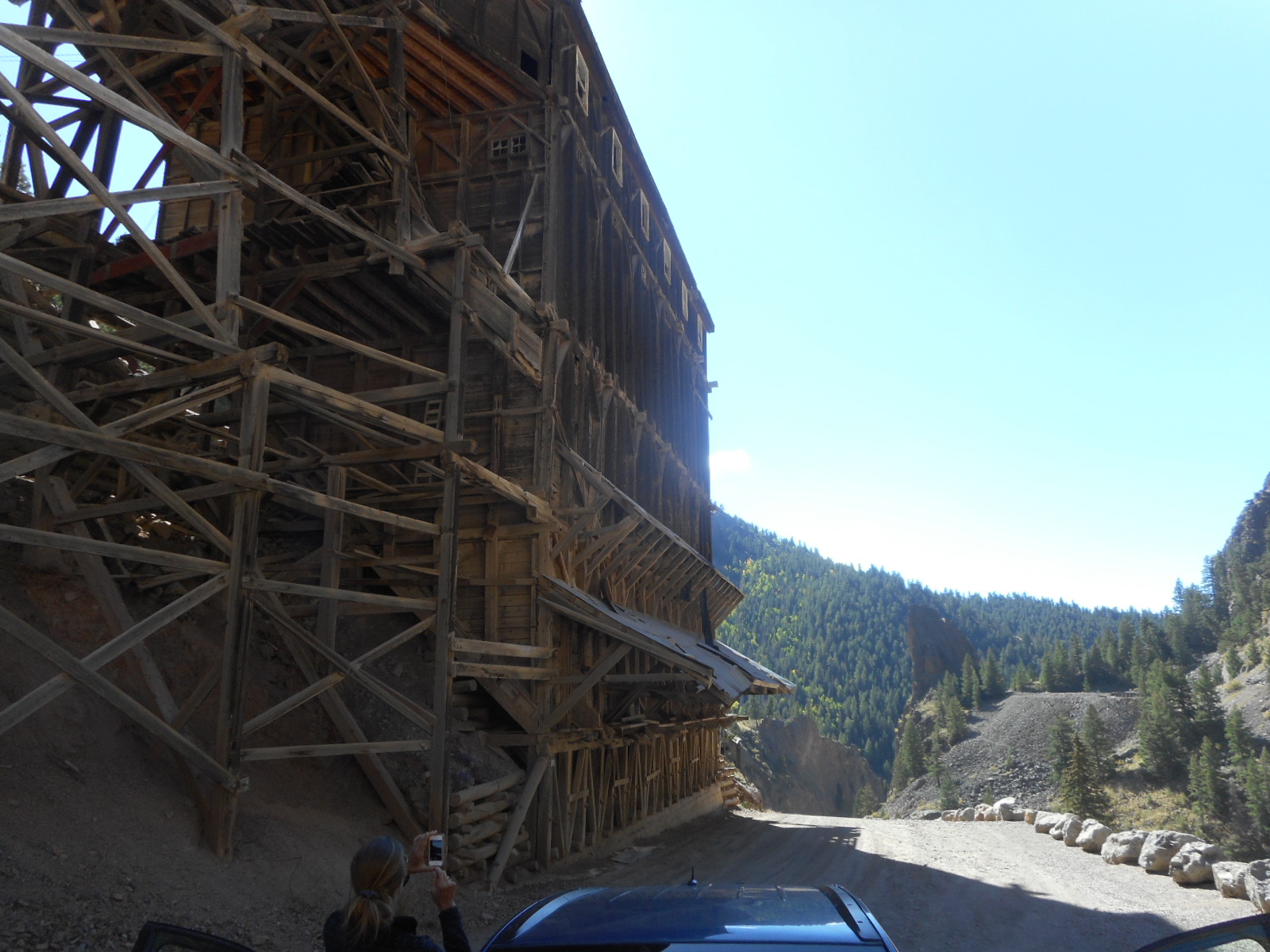
A name from the past popped up in Bachelor City. During its peak in the mid-1890’s, the gangster that dominated Bachelor City was Jefferson Randolph Smith, alias Soapy Smith. We actually learned about Soapy Smith when we were plying the Klondike Gold Rush. Apparently when Bachelor City played out, Soapy headed up to Dyea and Skagway Alaska in 1897 to pray on the gold rush miners. We had seen his old saloon outside of which he was gunned down in a shootout caused by his nefarious activities. We just love when we stumble into events or people that tie things together!

We enjoyed basically driving through time and history on this loop, noting that many of these historic mining buildings are still being used today, just for other purposes. For example, the Creede Fire Department is located in an old mining shaft just on the edge of town. If you are ever in the area, Creede is worth a bit of a detour.

Our trip to Creede provided us with several surprises we hadn’t expected. First we found wonderful hiking in the Rio Grande National Forest, which surrounds Alamosa and Creede and much of the area. On an old Forest Service road we found the Dead Man’s Gulch Trail, at least we thought we did. While signage and trail markings were apparently at a premium, we managed to find a 5 mile loop trail that did wind through a gulch. Luckily the Woman asked me to mark our car with our handheld GPS, which I did. After nearly 5 miles on the trail we seemed to be heading back to the Saturn, but we could not see it despite believing it to be there. It wasn’t until our GPS told us we were 700 feet away from the Saturn that we finally saw her – good call on the Woman’s part!

Signage on the road pointed to “La Ventana Natural Arch” so we went that way. When we arrived we found a lava curtain maybe 80 feet high and several football fields long. A lava curtain is formed when cooling lava is pushed up between a crack in the earth’s surface, and forms a long, narrow curtain of cooled basalt. Since its formation, water would seep into the curtain, freeze in the winter time and break off pieces of the curtain wall. Overtime this impressive formation grew – well worth the search to find.

Our next surprise was nearly as cool. Our last visit to Alamosa alerted us to the fact that the Rio Grande River, the famous dividing line between the US and Mexico, starts as far north as Colorado – it actually passes through downtown Alamosa. Not far from Creede is the Big Meadow Reservoir. While there is debate among those in Colorado, it is clear to us that the Big Meadow Reservoir is source of the Rio Grande. In this part of Colorado there are many bodies of water feeding into both the Rio Grande and the San Juan rivers, but you can back trace the Rio Grande right to this spot where a footbridge crosses the source.

Because of our luck, we have now been at both ends of the famous Rio Grande – and several spots along the way as well. While we were wintering in Port Aransas one year we headed down to drive the southern border of Texas on our way home. On the far southern tip of the Padre Islands off Brownsville we ventured down to the Las Palomas Wildlife Management Area, where the Rio Grande spills out into the Gulf of Mexico. It took some work to make our way out there and driving down the beach, but we are now glad we did – seeing both ends!

Our last discoveries made the Woman’s day! While not as well known or storied nearly as much as either the Pacific Crest Trail (about 2,700 miles long) or the Appalachian Trail (about 2,200 miles long), the Continental Divide Trail at over 3,100 miles is truly the Granddaddy of them all. Starting from the Crazy Cook Monument east of the Big Hatchet Mountains in New Mexico, it ends in Glacier National Park in Montana. Well, we found that there the Continental Divide Trail crossed US Highway 160 not all that far from Creede. US 160 is the main east/west highway that runs through Alamosa as well.

We headed to Wolf Creek Pass. It turns out that many moons ago when I was a young CPA manager auditing a ski resort near Purgatory ski slope, the early snows at Wolf Creek Pass provided enough snow that the ski slope there opened in early November, the earliest it had opened in its history. Well, I jumped on that, and it ended up to be the only time I ever did some Colorado mountain skiing. So the fact that we would now return there to hike some of the Continental Divide Trail seemed like destiny.

We found the trail markings that we needed to verify we were in the right place. The trail was far less heavily traveled than any of the AT that we hiked – it was very narrow, just enough room to plant your feet, and the brush growing along the trail actually grew across it for lack of many feet knocking it back. Like the AT it was steep and in some places rocky and wet. But all In all, it was a good trail and certainly fun to explore. We thought we would attempt to hike up to Lobo Overlook, but it turned out that was about 5 miles straight up from the parking area at Wolf Creek Pass. So we just hiked up a couple miles, got a good feel for the trail, and then headed back.

One of the most fun discoveries for the Woman was evidence that Trail Angels really exist. In all her readings about the AT and the PCT she had read about Trail Angels and found the idea really romantic. The AT and PCT, and CDT for that matter, are trails in the wilderness with no services of any kind for those who set out to hike them. Apparently there are good Samaritans who try to keep an eye on the hikers by leaving stashes of goodies for them out on the trail, perhaps when they would least expect the surprise. We stumbled over a large Coleman plastic cooler that had written on its cover “CDT thru-hikers”, and inside was a couple dozen chilled sodas.  On our way back to the car the Woman looked inside the cooler again, and now there was a huge multi-pack of snack chips as well. So now the Woman knows first-hand that Trail Angels do exist, and she knows that they also periodically visit their stashes to resupply them, just like it suggested in all the books she read!
The Woman found an unpaved road on her map that appeared to go from US 160 up to Lobo Overlook, so we gave it a shot. Sure enough, about 5 miles up that road we came to one of the most gorgeous overlooks we have ever seen. It was beautiful, but on a bald jutting out from the surrounding trees. As a result, it also may have been the windiest place we have ever been – well except maybe for Mount Washington in New Hampshire.

Several other adventures with brother Kevin and nephew Jake managed to happen. Golf at Cattails Golf Club, a day long Jeep ride with the top down (we managed to find another section of the Continental Divide Trail to hike at the Cumbres Pass), lots of hiking, and we even got a chance to have a little family geocache outing where brother Kevin and nephew Jake got to learn just the basics. A little curious from the experience, Jake has already gone online to see the huge number of caches hidden very near where he and his brother Will live in LA.

The only disappointment in our overall visit to Alamosa is that I had hoped to accomplish something on my bucket list for some time. I had wanted to ride the Cumbres and Toltec Historic Narrow Gauge Railroad for some time. Last time we had come through Alamosa the line had already closed for the season. This time it would still be open. Unfortunately the Woman asked me not to book reservations early when I wanted to in case her brother and nephew might want to come along with us. By the time she let me take a shot at booking reservations, all seats for the rest of the season were already sold out – dang! I guess it will have to keep its place on my bucket list for a while longer.

Talk to you soon!

Monday, September 28, 2015

Triumphant return

Several years ago we visited Palo Duro Canyon, a Texas State park. Unfortunately, we picked one of three days that year the back part of the park was closed. The park was hosting a Wounded Warrior 100 K race, and President George W. Bush was to be in attendance. Because of this, the Secret Service closed down the park beyond the visitor center, which is pretty much right at the entrance. So as we made our way from Northwestern Arkansas to Southern Colorado, we planned a stop by Amarillo – the park is about 30 miles South of there.

This time the park was open, although we weren’t too far into the park when we saw signs that the main road was closed for construction. Fortunately the roadway in the park is a big loop, so all we had to do was go the other way around and just turn around where the road was closed. So we did get to see all of it after all.

I wanted to hike to the Lighthouse, the signature formation of the park. Every brochure or website on the park displays a view of the Lighthouse. However, I learned that it was over a 3 mile hike into the formation, and then a return of the same. There were two issues to contend with – first, while it shouldn’t be this way in late September, the last I had checked the exterior temperature from the Saturn, she read 99 degrees. The sun was sweltering, and there is absolutely no shade on the hike. Second, I was trying to shake a fever from a virus that has bugged me the last day or so.

After careful consideration we took a pass, put it on the return to list, and just hiked some shorter hikes. Trust me, they were challenging enough with the heat and all over body aches. But we enjoyed touring the canyon bottom in what they refer to as the Grand Canyon of Texas. Allegedly Palo Duro Canyon is second only in size to the Grand Canyon in the US, so while a far cry from the Grand Canyon, it is a joy to visit.

After all the times we have driven through Amarillo on the I-40 we assumed we knew everything there was to do here – we were wrong. About 30 miles Northeast of Amarillo is Alibates National Monument – I just couldn’t believe we hadn’t discovered it before.

13,000 years ago Paleo-Indians known as the Clovis culture quarried flint here. Apparently the Monument represents one of few places in the US where agated dolomite is found. The agating process takes this already super hard limestone and gives it a very hard, brittle texture. When thin sections are chipped off, the resulting sharp edges are sharper than a razor blade. And yet the material could be carefully shaped to make knives, drills, arrow heads and spear heads. The Clovis of the time recognized how special it is and actually dug quarries in order to unearth a better quality of the native flint.

About 1,000 years ago, a Plains Village subgroup, known as the Antelope Creek people, recognized the specialness of this place. They also quarried flint here, but also built masonry structures close to the flint outcroppings along the Canadian River. The monument includes both the remains of the flint quarries as well as the archeological ruins of the dwellings.

The good news is that we just lucked out in the timing. You can only get to the ancient quarry sites and the dwellings on a Ranger led tour, which they conduct at only 10 AM and 2 PM. We actually arrived at about 10 minutes to 2, so we were jazzed. However, I checked the outdoor thermometer on the Saturn, and it now registered 103 degrees. The Rangers were reluctant to inform us that the 2 PM tour was cancelled due to the excessive heat. Apparently the 2 hour hiking tour is fairly strenuous and they just don’t risk it when it is this hot.

We still toured all the exhibits in the visitor center and took in the perfunctory video. While we were disappointed at missing the hike, something happened on our way back to Amarillo that emphasized just how hot it was. About half way back a warning light came on in the Saturn that I have never seen before. It looked like it was an overheating warning light, but I checked the engine temperature gauge and while running a bit warmer than normal, it was not overheating. The Woman got out the owner manual and looked up the nature of the warning light. Had it been illuminated solidly, it indeed would signify the engine overheating. This was flashing symbol, and the manual indicated that the temperature of the automatic transmission fluid had reached a critical level. The manual said that you had to pull over, put the transmission in park and let it idle until the light went off. It took about 20 minutes to settle down enough for the light to go off, but it finally did.

It appears that we made some good choices on skipping the long hikes.

Talk to you soon!

Saturday, September 26, 2015

Murfreesboro Arkansas

At our daughter Karen’s urging, we took a little jog south almost all the way back to Hope. When we had visited Hope, we had no idea this gem was just 40 miles North. Murfreesboro is the home of Crater of Diamonds State Park.

In 1906 Wesley Huddleston bought 160 acres outside Murfreesboro as a farm for his family. One day while preparing the fields, his eye fell upon several glittering pebbles. He sent the stones to a Little Rock jeweler who confirmed them to be actual diamonds. Archeologically, it turns out his land contained an ancient extinct volcano cone whose lava carried these precious stones near the surface, which is the reason diamonds exist here so near the topsoil. Over the decades many attempts were made to make this site into a commercially viable mining operation. However, although diamonds exist here in considerable quantities, their extraction is so costly as to make commercial mining uneconomical. All historic attempts to do so failed.

Based on geologic studies, this is the 8th richest diamond field in the world. The diamonds are relatively uniformly distributed, and the diamond field goes down 660 feet from the surface. The State of Arkansas purchased the otherwise dormant mining site in 1972, and operates it as a state park. The Park basically runs plows over the surface to create a network of furrows which guest are allowed to walk through, rake and dig in order to search for diamonds. If a guest finds a diamond, they are entitled to keep it.

As in most places we have been, no matter how hard you try to make the rules known, post signs, and verbally remind, it just doesn't seem to work. In my experience most dogs listen pretty good when you talk to them. Also in my experience, most dog owners don't. Apparently that is management's experience at Crater of Diamonds State Park as well.

The Woman and I grabbed our folding chairs, some gloves, a couple shovels, and rented a screen so we could sift through as much rock and dirt as we could handle, and take our chances at discovering a gem. Since we’ve discovered so many gems in our travels, we thought maybe we could duplicate it here. It does happen. In June a 31 year old woman found and 8 carat stone right on the surface. It turned out to be a flawless white diamond, and is being cut in a public display in Little Rock sometime soon. Speculation is that the stone, once cut, will likely fetch $350,000 at auction!

We had a great time at the Park, although we both found the prospecting to be far more work than we expected. Our bones and muscles reminded us of that by the minute the next day. We weren’t successful in uncovering another “gem”, but we did have a great time, and will take another shot at it if we ever get in the area again. It is the only place in the US where you can prospect for diamonds as a private citizen.

Talk to you soon!

Thursday, September 24, 2015

Northeastern Arkansas

On advice from Nick and Val we ventured to Bella Vista Arkansas. They had been here a couple weeks ago to visit Val’s grandparents who live here, and had some recommendations for us to check out. Apparently Bella Vista set out to be a golfing retirement community, and has been pretty successful at it, although the recent dark times have been a challenge for them as for others. Bella Vista is in the northeastern corner of Arkansas, just miles from both Missouri and Oklahoma.

Nearby Bentonville was and is the home of Walmart. In 1950 Sam Walton bought an existing five and dime store in downtown Bentonville. Opening on May 9 1950 with a one day “remodeling sale” he found it to his liking – none the least of which was due to the former owner being able to register only $72,000 in sales, and Sam in his first year was able to register over $105,000. At the time, he was a Ben Franklin franchise. It’s interesting to think that what he learned in being a Ben Franklin franchisee eventually created the largest retail company in the world, and yet Ben Franklin Company itself has long since bit the dust. His original store, at least the front, is still across the street from the main town square.

The old store façade is now the front for the Walmart Museum, which chronicles the birth and growth of the conglomerate, and memorializes its founder. I have to admit I always had a poor personal opinion of the Company, viewing them as viscously working to put their competitors out of business with loss pricing, and then raising prices when all the competitors were gone. I saw them as destroying the fabric of smaller communities. Sam’s mission seems a bit more worthy as it is cast in the Museum. Since early on he had documented his mission as to create a way for average Americans to be able to stretch their dollars, buy more, and therefor improve their standards of living. Sounds nicer than my perspective.

Sam’s original office with all its furnishings was great fun. The statistics were staggering, and all the Companies that were spawned – Walmart Financial, Walmart Broadcasting, Walmart Logistics – pretty much any kind of supporting service you might need to run a multi-location retail establishment with thousands of employees and customers is now a separate company under the Walmart umbrella. And most – maybe all for all I know – have a headquarters building in Bentonville.

When stopped for lunch at a Thai restaurant downtown one day, it seemed like all the other folk there were Walmart executives. We overheard all kinds of discussions about employee training, livable wage, trucking, you name it. From what I can tell, if you live in Bentonville you can’t help but be immersed into the world of Walmart.

We visited the Bluff Dwellers Cavern just across the border in Noel Missouri, maybe 20 miles North of Bella Vista. Privately owned attractions are pretty common in this part of the world, and Bluff Dwellers Cavern is one of them. Discovered in 1925 by Arthur Browning on land he owned, the family has given visitors private tours since its inception. Through archeological work Browning was able to prove that the cavern exterior has been occupied for over 12,000 years.

I mentioned that the Woman had some disappointment at Mammoth Cave. While it was immense and really interesting, it was a dry cave, capped by a rock layer that prevented water from seeping in. Because of that there are no stalactites or stalagmites that she associates in her mind with a “beautiful” cave. Well, she got her fix here. The cave system here is very wet, alive and growing. While not the biggest formations we have ever seen, the variety and uniqueness made our visit enjoyable.

A couple of the highlights of the cave really excited us:

·         Bats live in this cave, just like they do in Mammoth. However, we saw no bats in Mammoth, and we no sooner entered Bluff Dwellers Cavern and there were some hanging from the ceiling.

·         They had a small but great museum of artifacts. Crystals and geodes were numerous and some were very unique. Pictures of the early cavern buildings, tour groups and family members were fun to look at. However, the coolest item in the museum was a petrified bird’s nest, complete with petrified eggs.

·         Although most never see it, the caves are rampant with wildlife. For some reason the day we were there the common cave salamanders were out and about. They are salmon in color, and the ones we saw were 4-5 inches long. I bet we saw dozen of them.

The Cavern is still a family business, today run by the grandchildren of Arthur Browning who discovered it. Until recently it was run by his daughter. However, she gave her last tour at the tour guide at the age of 87 when her grandkids encouraged here to retire.

We sauntered down to Fayetteville and drove around the campus of the University of Arkansas. It seemed like a pleasant campus, but the vicious Razorback mascot symbols everywhere became somewhat overwhelming. We also visited the Crystal Bridges Museum of Art. This is a spectacular art museum, both for its unique architecture and the quality of its collection. The Museum is sponsored by Walmart (of course) so admission is free to all. We were surprised to see original works of Homer Winslow, Georgia O’Keeffe, Gilbert Stuart, Norman Rockwell, James Whistler, Pablo Picasso and so much more.

Another bonus – a significant collection of Andy Warhol’s work was currently in residence at Crystal Bridges. While I always thought of Warhol as more current, he was born in 1928 and died in 1987. He is probably best known for his work done in the 1960’s. We really enjoyed this exhibit because not only could we relate to some of the actual images. It was just interesting to see a more comprehensive exhibit of his work. This museum is definitely worth a visit.

When surfing the web for tourism ideas I discovered that the first home the Bill and Hillary Clinton lived in as newlyweds was here. Apparently Bill had asked Hillary to marry him on at least one occasion and she had declined. When he got his professorship at the UA law school he asked her to move there. She had no interest in moving to Arkansas but did visit him there. On one visit, she saw a cute very east coast looking brick home just a block or so from the law building, and commented on it. Apparently Bill took that signal, bought the home and used it to lure her not only to marry him, but to move to Fayetteville, where she became a law professor as well. They were married in the living room of this home.

We got a little bonus when we were there. We learned that all the Arkansas based Clinton historical sites had gotten together and created a passport that you could get stamped when you visited. On other trips we had visited his boyhood home in Hope, his presidential library in Little Rock, his high school in Hot Springs, so it turned out that by visiting this site, we had completed our Arkansas “Billgrimage”! The kind docent there took pity on us, since we visited those sites before the passport was developed, and awarded us the William Jefferson Clinton pins that go along with completing the Billgrimage.

We saw the aqua colored tile that Bill had personally laid in front of the fireplace – it looked like he did a really nice job. Hillary would later comment that of course it should look nice, when you take a weekend project and make it last 6 months. We also learned that the Clintons were not the first notable people to own this home. Two of the biggest processed chicken distributors in the US happened to hail from this part of Arkansas, the Tyson family and the Swanson family. The founder of Swanson foods used to own the Clinton home, and used to experiment with recipes in its modest kitchen. Allegedly the recipe for the Swanson chicken pot pie was developed in this very house.

Having completed our Arkansas exploration of Slick and president elect Hilary, it was time to move on.

Talk to you soon!

Tuesday, September 22, 2015

Wrapping up Eureka Springs

We spent most our time roaming the zigzag Victorian streets of Eureka Springs. But there were some things not far away that we wanted to venture to.

Pea Ridge National Military Park was only about 20 miles from here – but of course the snakelike roads through the Ozarks turn that into 40 minutes easy. On March 6 through 8,1862, about 16,000 Confederate troops engaged about 10,000 Union troops at Pea Ridge Arkansas. Despite superior forces, poor command communication resulted in the Confederates not taking advantage of their superior strength, and eventually lost the battle. Their loss pretty much salvaged Missouri for the Union, which remained neutral for the remainder of the war.

While the trees have changed since 1862, the terrain has remained untouched. We toured all the major battle sites from those three horrific days. The videos and interactive displays in the Visitor Center made it easy to follow the movements of the troops out on the Ridge as it would have happened 150 years ago.

The Park contains a renovated Elkhorn Tavern, which played an important role in the battles. The Elkhorn, first built in 1833, was on high ground, and was originally held by the Confederate forces as their command headquarters. On March 7 Union forces advanced on the Tavern, driving out the Confederate forces and taking for use as a field hospital. The Tavern area would be a focal point for fighting during the battle, with the Confederate forces eventually regaining control. However, during nearby engagements, two Confederate Generals were killed, the most senior casualties in the entire Civil War. The death of these two Generals put their forces in disarray which contributed to the Confederate loss despite having a greater than 3 to 2 advantage.

Confederate losses in this battle were 2,000 compared to about 1,400 for the Union, well over 10% of each side’s forces. It is interesting how these terrible locations seem to be a vortex for bad events. It turns out that Pea Ridge was not only a Civil War battlefield, but some 20 years earlier it was part of the Trail of Tears, the route of the forced migration of Native Americans where so many perished.

Another connection pops up - on the Owens family homestead site in Branson Missouri we had visited a known cave where a confederate soldier fleeing from Pea Ridge had hidden until he was safe.

South of Eureka Springs on Arkansas 23 is the second best motorcycle cruising road in America, according to followers of both USA Today and the Discovery Channel. With all the famous biker roads we have seen on this journey, we couldn’t pass this opportunity up. Known as the Pig Trail, it is not nearly as compact and snaky as the Tail of the Dragon. But since it winds along many ridges in the Ozarks with spectacular views, I could see an argument for it being better. Interestingly enough we came to a spot when the Pig Trail was closed due to a heavy storm and the highway being washed out. Luckily we had already done the portion of the Trail that we really had wanted to see and drive.

On our way to the Pig Trail we stumbled across Quigley’s Castle. Albert and Elise Quigley lived outside Eureka Springs with their robust family. Elise had been talking for years about the kind of house she wanted to build. But Albert, who worked at a local lumber mill, got enough of construction lumber during the day and kept putting off the idea. One day in 1943 when Albert went to work, Elise gathered the family and completely disassembled their 3 room house. Needless to say, construction of Elise’s dream commenced soon.

Elise had a vision of a home big enough for the family, but that would bring the outdoors inside as well. She basically designed a home where the living spaces were receded from the walls by 4 feet of earth, and the 4 feet of earth is used essentially as a green house. Not just small plants but giant trees live in that space. Elise’s granddaughter, who now resides in the home and gives tours, told us that the two story trees that we were looking at were the same trees her grandmother had planted in the 1940’s. Odd, but really interesting, Castle Quigley is on the National Register of Historic Places.

When we were in Hot Springs we learned about Carrie Nation. During Prohibition guys like Al Capone and other Chicago gangsters set up bars and casinos in Hot Springs – we had visited Capone’s. The local officials and police got paid off – maybe even frequented these places, but they were notorious. Carrie Nation was a temperance leader who brought a hatchet along with her wherever she went. She had chopped up Capone’s wooden bar in Hot Springs, which got her a lot of publicity.

Carrie Nation eventually settled down in Eureka Springs. We found her home near one of the 63 springs we were trying to find around town. She was so famous for her actions to physically chop up illegal wooden bars wherever she went that the press named her home in Eureka Springs Hatchet Hall.

On the way to Pea Ridge we discovered several gems, but only because Brenda took us on a shortcut on some one-lane roads labeled as a legitimate Arkansas highway. So much for putting her on her Truck setting where she swears she will avoid roads inappropriate for large trucks! In the little town of Beaver we found the Little Golden Gate Bridge of Arkansas. The last of the wooden one lane state highway bridges to be still in use, the bridge looks amazingly like the Golden Gate Bridge on a reduced scale.

The Little Golden Gate crosses Beaver Lake, a lake made from one of the many dams along the White River. The White River, as we learned, was tamed by the Army Corps of Engineers, the same White River that formed Lake Taneycomo in Branson that we had paddled on and enjoyed so much. We keep bumping into the White River as we tool around the Ozarks – it is an impressive body of water. An 1850’s era railroad bridge still spans the White River at Beaver Arkansas very near the Little Golden Gate.

We lucked out again. A curious building called Castle Rogues Manor overlooks the city of Beaver and both bridges. It is the lifelong work of a local gentleman who saw the land, had a dream, and dedicated his life to building it. We learned that they don’t have scheduled times – you have to call ahead and schedule a tour. But the owner said he would be happy to meet us there in an hour – we had a picnic lunch – and Beaver City Lake Park had a nice picnic area right on the White River. I love it when things fall together!

Interestingly when we stopped in at Beaver City Lake Park, they not only had a picnic area and some hiking, but also had a campground with electricity, a beach and a boat ramp. Other than the few trees that provided some well appreciated shade, you could see the lake from anywhere in the Park. It made me wonder why this warning sign was necessary.

The building was never exactly meant to be a home – he wasn’t sure what it would turn into when he started building it. It is all hand made from local stone and wood. He has tried to draw from many different architectural styles from all over the world - domes, massive hearth, expansive balconies, etc. But the only consistent theme seems to be over the top, impressive carpentry and stone work.

The hand carved wooden flooring as well as the maze of stair cases in the upper floors remind you of an Escher maze – you see it all and it looks like it has perspective, but then you realize you are not really sure you can get from point A to point B. At some point when funding was getting to be a real issue he realized that folk looking for a unique wedding or catered event had been visiting. Now he uses such catered events, with occasional overnight stays, as the way to fund his continued construction. There is nothing particularly historic about Castle Rogues Manor other than its location, but we had a great time touring it.

Our other gem near Beaver was the Blue Spring Heritage Site. The Blue Spring has been the location of human habitation for perhaps 20,000 years based on archeological work. The spring produces the most consistent and highest volume of water in the Eureka Springs area. Nestled in a valley, it spews 38 million gallons of pure spring water into the White River daily. Its name comes from the distinctive blue glow of the water in the pool created by the spring.

In addition to just taking in the beauty of the spring we hiked to find where the spring water spilled into the White River, as well as the sites where evidence of human habitation were discovered under the bluffs. In the visitor center we learned about efforts to explore the source of the spring, exploring it under water using scuba gear. They have only been able to dive about 300 feet into the caves under the spring before they became too small to penetrate, so they can only speculate. Based on water testing, they actually believe the water may originate in Alaska.

We wanted to hike to what is allegedly the most photographed object in the State of Arkansas – Whitaker Point. Also known as Hawksbill Crag, it is an immense boulder jutting out over the Ozark Mountain Wilderness near the Buffalo Wild and Scenic River managed jointly by the National Park Service and the US Forest Service. It’s a bit of a drive to get to the trailhead, and the last 6 miles of the drive are on unpaved roads, but once you reach the Point, there is no doubt it was worth it.

It’s a 4 mile round trip hike out to the Point. About a mile into the hike, you begin to round a huge dome of a peak, so for the last mile you are continuously provided spectacular views out over the Ozark Mountains and its dense forests. Even if we never reached the Point the hike would have proved worthwhile. But when you actually reach the goal, you totally understand the name Hawksbill Crag – it does look exactly like a hawk’s bill.

After the great hike I wanted to take in the Buffalo National River. When we were near the Devil’s Triangle in Tennessee we had visited the Obed Wild and Scenic River and found it to live up to its name. Folks in kayaks were busily charging the rapids and having a great time. When we arrived at the Buffalo, we learned that it was neither. While the Buffalo River at 135 miles is one of the longest rivers in the US without any dams on it, apparently it is seasonal. Although the National Park Service manages over 95,000 acres of land along the Buffalo, it only has water in it in the spring, or after heavy rains. It was a disappointment, but the Hawksbill Crag made the visit wonderful!

The last gem we discovered was the Bank of Eureka Springs, founded on May 1, 1912. On Spring Street in downtown Eureka Springs is the location they moved to in 1946, and it is the only working bank in the US that you can legally take photographs in – while it is a working bank, it is also a historical museum. Collections of equipment, furniture and records from the early days of the bank are all over. We met John Fuller Cross, Chairman and President of the bank, and he walked us around and showed us all the interesting artifacts.

John is the grandson of Claude Fuller, former President of the bank and Congressman for Arkansas from 1929 to 1939. The elder Fuller was responsible for much of the legislation that resulted in the Army Corps controlling the White River, reducing flood devastation, and providing reliable electricity to the remote Ozark communities. John asked me if we were currently collecting Social Security payments. When I said yes, he pointed to a photo of his grandfather and said “You can thank him for that.” It turns out that Claude Fuller sponsored the legislation that ultimately resulted in Social Security. So we met the grandson of the guy who helped supplement our current lifestyle – cool!

We’re kinda sad to leave the Ozarks, they are so much more beautiful than we imagined. However they also have their own rules to live by. Here is how they warn hikers on the trails to honor private property and no-trespassing signs!

Talk to you soon!